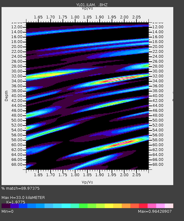
ILAM YL.ILAM - Earthquake Result Viewer
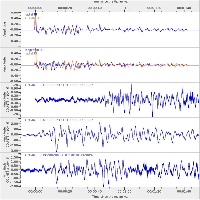
Earthquake location: Southeast Indian Ridge
Earthquake latitude/longitude: -47.8/99.8
Earthquake time(UTC): 2002/06/13 (164) 01:27:19 GMT
Earthquake Depth: 10 km
Earthquake Magnitude: 5.5 MB, 6.6 MS, 6.6 MW, 6.5 MW
Earthquake Catalog/Contributor: WHDF/NEIC
Network: YL Himalayan Nepal Tibet Experiment
Station: ILAM YL.ILAM
Lat/Lon: 26.91 N/87.92 E
Elevation: 1181 m
Distance: 75.1 deg
Az: 349.083 deg
Baz: 171.779 deg
Ray Param: 0.05187689
Estimated Moho Depth: 33.0 km
Estimated Crust Vp/Vs: 1.98
Assumed Crust Vp: 6.236 km/s
Estimated Crust Vs: 3.153 km/s
Estimated Crust Poisson's Ratio: 0.33
Radial Match: 89.97375 %
Radial Bump: 400
Transverse Match: 84.40281 %
Transverse Bump: 400
SOD ConfigId: 16844
Insert Time: 2010-02-26 15:56:32.611 +0000
GWidth: 2.5
Max Bumps: 400
Tol: 0.001

Signal To Noise

ChannelStoNSTALTA
YL:ILAM: :BHZ:20020613T01:38:30.342009Z2.196892.574883E-71.17205815E-7
YL:ILAM: :BHN:20020613T01:38:30.342009Z1.11163281.2320187E-71.1082965E-7
YL:ILAM: :BHE:20020613T01:38:30.342009Z0.78801067.270053E-89.225831E-8
Arrivals
Ps5.3 SECOND
PpPs15 SECOND
PsPs/PpSs21 SECOND