You are here: Home > Network List > NE - New England Seismic Network Stations List
> Station EMMW Machias, ME, USA > Earthquake Result Viewer
EMMW Machias, ME, USA - Earthquake Result Viewer
*The percent match for this event was below the threshold and hence no stack was calculated.
| Earthquake location: |
Oaxaca, Mexico |
| Earthquake latitude/longitude: |
16.5/-97.6 |
| Earthquake time(UTC): |
2018/02/19 (050) 06:57:01 GMT |
| Earthquake Depth: |
40 km |
| Earthquake Magnitude: |
5.9 Mww |
| Earthquake Catalog/Contributor: |
NEIC PDE/us |
|
| Network: |
NE New England Seismic Network |
| Station: |
EMMW Machias, ME, USA |
| Lat/Lon: |
44.71 N/67.46 W |
| Elevation: |
35 m |
|
| Distance: |
37.9 deg |
| Az: |
35.672 deg |
| Baz: |
231.679 deg |
| Ray Param: |
$rayparam |
*The percent match for this event was below the threshold and hence was not used in the summary stack. |
|
| Radial Match: |
58.39814 % |
| Radial Bump: |
400 |
| Transverse Match: |
83.46039 % |
| Transverse Bump: |
400 |
| SOD ConfigId: |
2546091 |
| Insert Time: |
2018-03-05 06:58:27.281 +0000 |
| GWidth: |
2.5 |
| Max Bumps: |
400 |
| Tol: |
0.001 |
|
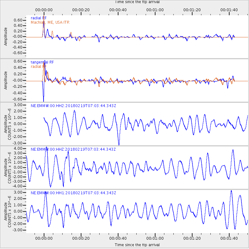
Signal To Noise
| Channel | StoN | STA | LTA |
| NE:EMMW:00:HHZ:20180219T07:03:44.343Z | 1.8540696 | 2.773421E-6 | 1.4958559E-6 |
| NE:EMMW:00:HH1:20180219T07:03:44.343Z | 1.7737746 | 1.6770861E-6 | 9.4548994E-7 |
| NE:EMMW:00:HH2:20180219T07:03:44.343Z | 0.6796076 | 7.0545815E-7 | 1.0380375E-6 |
| Arrivals |
| Ps | |
| PpPs | |
| PsPs/PpSs | |


