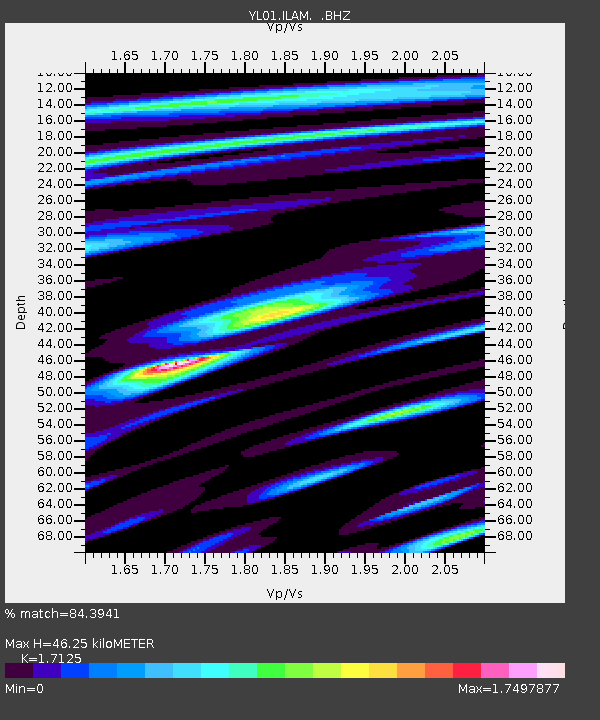
ILAM YL.ILAM - Earthquake Result Viewer
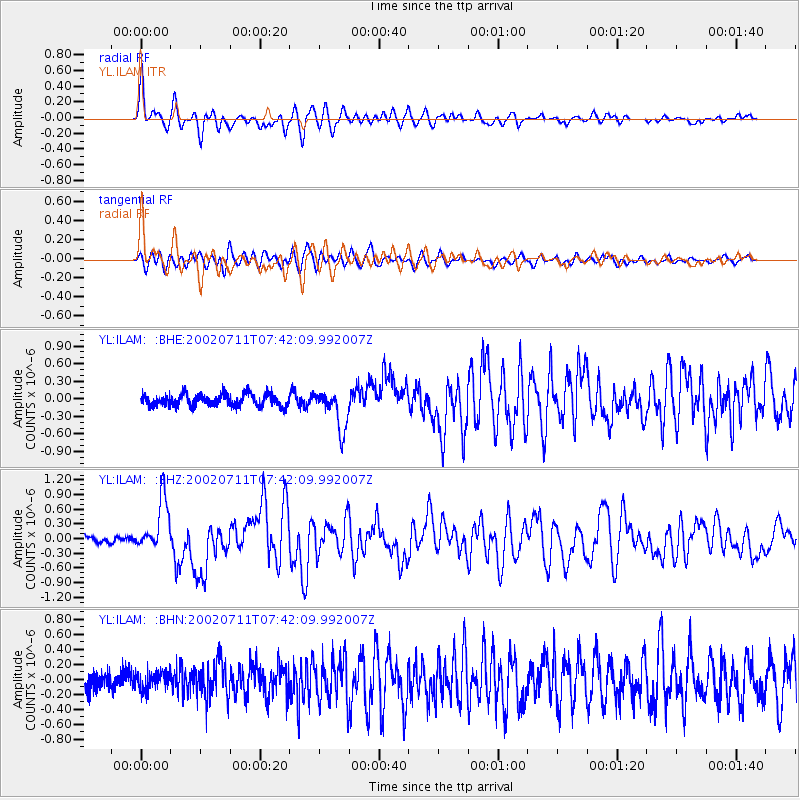
Earthquake location: Taiwan Region
Earthquake latitude/longitude: 24.1/122.3
Earthquake time(UTC): 2002/07/11 (192) 07:36:26 GMT
Earthquake Depth: 44 km
Earthquake Magnitude: 5.6 MB, 5.6 MS, 5.8 MW, 5.8 MW
Earthquake Catalog/Contributor: WHDF/NEIC
Network: YL Himalayan Nepal Tibet Experiment
Station: ILAM YL.ILAM
Lat/Lon: 26.91 N/87.92 E
Elevation: 1181 m
Distance: 31.1 deg
Az: 282.58 deg
Baz: 87.496 deg
Ray Param: 0.079108775
Estimated Moho Depth: 46.25 km
Estimated Crust Vp/Vs: 1.71
Assumed Crust Vp: 6.236 km/s
Estimated Crust Vs: 3.641 km/s
Estimated Crust Poisson's Ratio: 0.24
Radial Match: 84.3941 %
Radial Bump: 400
Transverse Match: 60.02639 %
Transverse Bump: 400
SOD ConfigId: 16844
Insert Time: 2010-02-26 15:56:37.274 +0000
GWidth: 2.5
Max Bumps: 400
Tol: 0.001

Signal To Noise

ChannelStoNSTALTA
YL:ILAM: :BHZ:20020711T07:42:09.992007Z6.13688475.294472E-78.627297E-8
YL:ILAM: :BHN:20020711T07:42:09.992007Z0.83277931.1163322E-71.3404899E-7
YL:ILAM: :BHE:20020711T07:42:09.992007Z3.39586333.4088598E-71.0038271E-7
Arrivals
Ps5.7 SECOND
PpPs19 SECOND
PsPs/PpSs24 SECOND