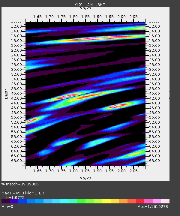
ILAM YL.ILAM - Earthquake Result Viewer

Earthquake location: Mariana Islands
Earthquake latitude/longitude: 14.1/146.2
Earthquake time(UTC): 2002/08/14 (226) 13:57:52 GMT
Earthquake Depth: 30 km
Earthquake Magnitude: 6.1 MB, 6.4 MS, 6.5 MW, 6.4 MW
Earthquake Catalog/Contributor: WHDF/NEIC
Network: YL Himalayan Nepal Tibet Experiment
Station: ILAM YL.ILAM
Lat/Lon: 26.91 N/87.92 E
Elevation: 1181 m
Distance: 55.6 deg
Az: 293.046 deg
Baz: 90.937 deg
Ray Param: 0.0646176
Estimated Moho Depth: 45.0 km
Estimated Crust Vp/Vs: 1.98
Assumed Crust Vp: 6.236 km/s
Estimated Crust Vs: 3.153 km/s
Estimated Crust Poisson's Ratio: 0.33
Radial Match: 89.39866 %
Radial Bump: 400
Transverse Match: 81.92808 %
Transverse Bump: 400
SOD ConfigId: 16844
Insert Time: 2010-02-26 15:56:38.673 +0000
GWidth: 2.5
Max Bumps: 400
Tol: 0.001

Signal To Noise

ChannelStoNSTALTA
YL:ILAM: :BHZ:20020814T14:06:54.391006Z5.0764611.0502508E-62.0688641E-7
YL:ILAM: :BHN:20020814T14:06:54.391006Z1.42766455.942217E-74.1621942E-7
YL:ILAM: :BHE:20020814T14:06:54.391006Z2.11262584.8778924E-72.3089237E-7
Arrivals
Ps7.4 SECOND
PpPs21 SECOND
PsPs/PpSs28 SECOND