You are here: Home > Network List > US - United States National Seismic Network Stations List
> Station DGMT Dagmar, Montana, USA > Earthquake Result Viewer
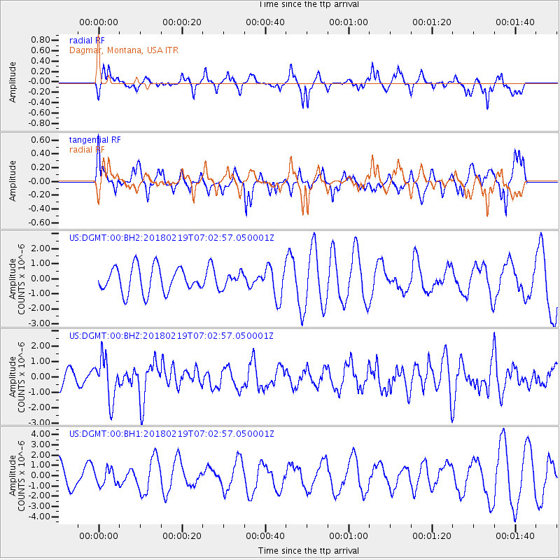
DGMT Dagmar, Montana, USA - Earthquake Result Viewer
*The percent match for this event was below the threshold and hence no stack was calculated.
| Earthquake location: |
Oaxaca, Mexico |
| Earthquake latitude/longitude: |
16.5/-97.6 |
| Earthquake time(UTC): |
2018/02/19 (050) 06:57:01 GMT |
| Earthquake Depth: |
40 km |
| Earthquake Magnitude: |
5.9 Mww |
| Earthquake Catalog/Contributor: |
NEIC PDE/us |
|
| Network: |
US United States National Seismic Network |
| Station: |
DGMT Dagmar, Montana, USA |
| Lat/Lon: |
48.47 N/104.20 W |
| Elevation: |
0.0 m |
|
| Distance: |
32.3 deg |
| Az: |
351.759 deg |
| Baz: |
168.076 deg |
| Ray Param: |
$rayparam |
*The percent match for this event was below the threshold and hence was not used in the summary stack. |
|
| Radial Match: |
59.095905 % |
| Radial Bump: |
336 |
| Transverse Match: |
52.88129 % |
| Transverse Bump: |
400 |
| SOD ConfigId: |
2546091 |
| Insert Time: |
2018-03-05 06:58:51.957 +0000 |
| GWidth: |
2.5 |
| Max Bumps: |
400 |
| Tol: |
0.001 |
|
Signal To Noise
| Channel | StoN | STA | LTA |
| US:DGMT:00:BHZ:20180219T07:02:57.050001Z | 2.494774 | 1.3710269E-6 | 5.4955956E-7 |
| US:DGMT:00:BH1:20180219T07:02:57.050001Z | 0.6184428 | 7.462551E-7 | 1.2066681E-6 |
| US:DGMT:00:BH2:20180219T07:02:57.050001Z | 0.55811673 | 4.7079337E-7 | 8.435392E-7 |
| Arrivals |
| Ps | |
| PpPs | |
| PsPs/PpSs | |


