You are here: Home > Network List > US - United States National Seismic Network Stations List
> Station HAWA Hanford, Washington, USA > Earthquake Result Viewer
HAWA Hanford, Washington, USA - Earthquake Result Viewer
*The percent match for this event was below the threshold and hence no stack was calculated.
| Earthquake location: |
Tonga Islands |
| Earthquake latitude/longitude: |
-18.7/-174.1 |
| Earthquake time(UTC): |
2021/09/01 (244) 08:21:09 GMT |
| Earthquake Depth: |
75 km |
| Earthquake Magnitude: |
5.2 Mww |
| Earthquake Catalog/Contributor: |
NEIC PDE/us |
|
| Network: |
US United States National Seismic Network |
| Station: |
HAWA Hanford, Washington, USA |
| Lat/Lon: |
46.39 N/119.53 W |
| Elevation: |
364 m |
|
| Distance: |
81.4 deg |
| Az: |
34.774 deg |
| Baz: |
231.346 deg |
| Ray Param: |
$rayparam |
*The percent match for this event was below the threshold and hence was not used in the summary stack. |
|
| Radial Match: |
57.47933 % |
| Radial Bump: |
396 |
| Transverse Match: |
51.538654 % |
| Transverse Bump: |
400 |
| SOD ConfigId: |
25131211 |
| Insert Time: |
2021-09-15 08:43:19.035 +0000 |
| GWidth: |
2.5 |
| Max Bumps: |
400 |
| Tol: |
0.001 |
|
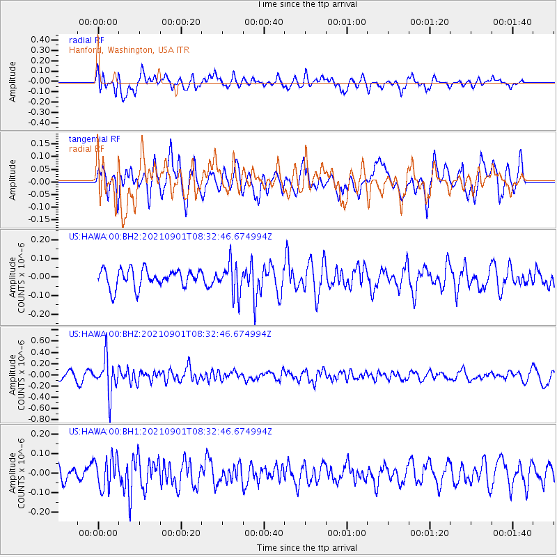
Signal To Noise
| Channel | StoN | STA | LTA |
| US:HAWA:00:BHZ:20210901T08:32:46.674994Z | 5.077994 | 3.204029E-7 | 6.309636E-8 |
| US:HAWA:00:BH1:20210901T08:32:46.674994Z | 1.0790467 | 7.961469E-8 | 7.378244E-8 |
| US:HAWA:00:BH2:20210901T08:32:46.674994Z | 1.7816553 | 8.6274824E-8 | 4.842397E-8 |
| Arrivals |
| Ps | |
| PpPs | |
| PsPs/PpSs | |


