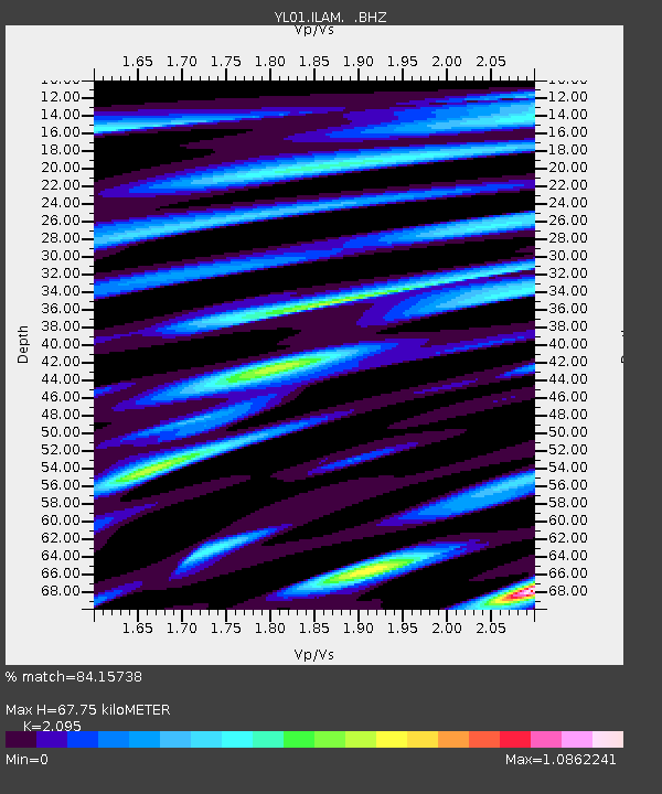
ILAM YL.ILAM - Earthquake Result Viewer
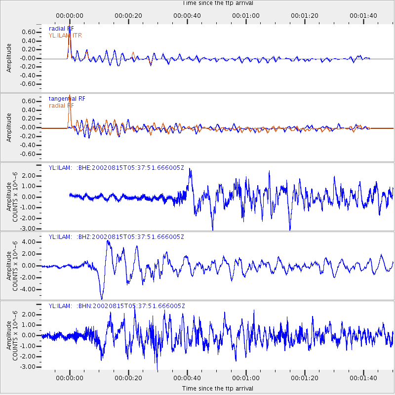
Earthquake location: Sulawesi, Indonesia
Earthquake latitude/longitude: -1.2/121.3
Earthquake time(UTC): 2002/08/15 (227) 05:30:26 GMT
Earthquake Depth: 10 km
Earthquake Magnitude: 5.7 MB, 5.8 MS, 6.2 MW, 6.1 MW
Earthquake Catalog/Contributor: WHDF/NEIC
Network: YL Himalayan Nepal Tibet Experiment
Station: ILAM YL.ILAM
Lat/Lon: 26.91 N/87.92 E
Elevation: 1181 m
Distance: 42.6 deg
Az: 313.436 deg
Baz: 125.606 deg
Ray Param: 0.07307129
Estimated Moho Depth: 67.75 km
Estimated Crust Vp/Vs: 2.10
Assumed Crust Vp: 6.236 km/s
Estimated Crust Vs: 2.977 km/s
Estimated Crust Poisson's Ratio: 0.35
Radial Match: 84.15738 %
Radial Bump: 400
Transverse Match: 84.4577 %
Transverse Bump: 400
SOD ConfigId: 16844
Insert Time: 2010-02-26 15:56:40.116 +0000
GWidth: 2.5
Max Bumps: 400
Tol: 0.001

Signal To Noise

ChannelStoNSTALTA
YL:ILAM: :BHZ:20020815T05:37:51.666005Z2.1250682.0842099E-79.807733E-8
YL:ILAM: :BHN:20020815T05:37:51.666005Z1.50233892.2172671E-71.4758768E-7
YL:ILAM: :BHE:20020815T05:37:51.666005Z1.13192891.8547995E-71.6386184E-7
Arrivals
Ps13 SECOND
PpPs32 SECOND
PsPs/PpSs44 SECOND