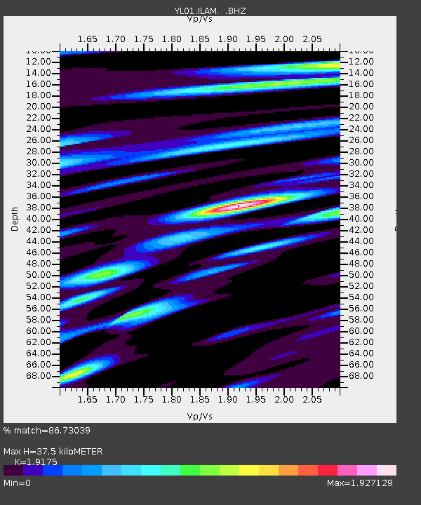
ILAM YL.ILAM - Earthquake Result Viewer
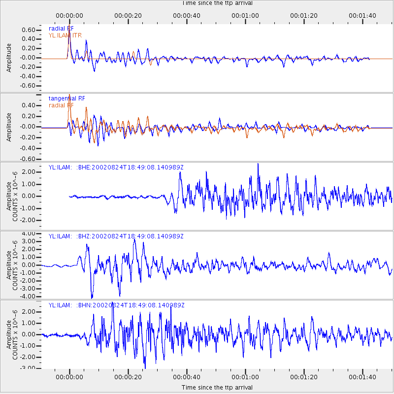
Earthquake location: Kuril Islands
Earthquake latitude/longitude: 43.1/146.1
Earthquake time(UTC): 2002/08/24 (236) 18:40:53 GMT
Earthquake Depth: 43 km
Earthquake Magnitude: 5.9 MB, 5.8 MS, 6.2 MW, 6.1 MW
Earthquake Catalog/Contributor: WHDF/NEIC
Network: YL Himalayan Nepal Tibet Experiment
Station: ILAM YL.ILAM
Lat/Lon: 26.91 N/87.92 E
Elevation: 1181 m
Distance: 49.4 deg
Az: 270.696 deg
Baz: 55.092 deg
Ray Param: 0.06864694
Estimated Moho Depth: 37.5 km
Estimated Crust Vp/Vs: 1.92
Assumed Crust Vp: 6.236 km/s
Estimated Crust Vs: 3.252 km/s
Estimated Crust Poisson's Ratio: 0.31
Radial Match: 86.73039 %
Radial Bump: 400
Transverse Match: 92.79298 %
Transverse Bump: 400
SOD ConfigId: 16844
Insert Time: 2010-02-26 15:56:42.413 +0000
GWidth: 2.5
Max Bumps: 400
Tol: 0.001

Signal To Noise

ChannelStoNSTALTA
YL:ILAM: :BHZ:20020824T18:49:08.140989Z4.1582775.0008714E-71.2026307E-7
YL:ILAM: :BHN:20020824T18:49:08.140989Z1.48499561.08270264E-77.290948E-8
YL:ILAM: :BHE:20020824T18:49:08.140989Z4.2304212.5188697E-75.954182E-8
Arrivals
Ps5.8 SECOND
PpPs17 SECOND
PsPs/PpSs22 SECOND