You are here: Home > Network List > WY - Yellowstone Wyoming Seismic Network Stations List
> Station YHH Holmes Hill, YNP, WY, USA > Earthquake Result Viewer
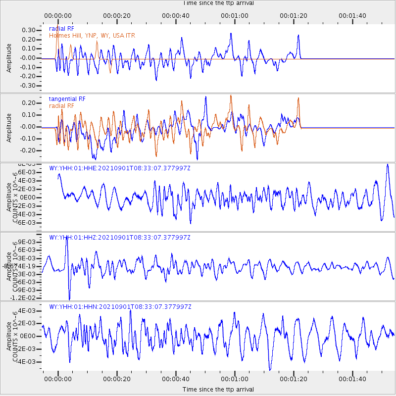
YHH Holmes Hill, YNP, WY, USA - Earthquake Result Viewer
*The percent match for this event was below the threshold and hence no stack was calculated.
| Earthquake location: |
Tonga Islands |
| Earthquake latitude/longitude: |
-18.7/-174.1 |
| Earthquake time(UTC): |
2021/09/01 (244) 08:21:09 GMT |
| Earthquake Depth: |
75 km |
| Earthquake Magnitude: |
5.2 Mww |
| Earthquake Catalog/Contributor: |
NEIC PDE/us |
|
| Network: |
WY Yellowstone Wyoming Seismic Network |
| Station: |
YHH Holmes Hill, YNP, WY, USA |
| Lat/Lon: |
44.79 N/110.85 W |
| Elevation: |
2717 m |
|
| Distance: |
85.4 deg |
| Az: |
39.632 deg |
| Baz: |
238.093 deg |
| Ray Param: |
$rayparam |
*The percent match for this event was below the threshold and hence was not used in the summary stack. |
|
| Radial Match: |
47.784115 % |
| Radial Bump: |
400 |
| Transverse Match: |
54.204575 % |
| Transverse Bump: |
400 |
| SOD ConfigId: |
25131211 |
| Insert Time: |
2021-09-15 08:46:39.733 +0000 |
| GWidth: |
2.5 |
| Max Bumps: |
400 |
| Tol: |
0.001 |
|
Signal To Noise
| Channel | StoN | STA | LTA |
| WY:YHH:01:HHZ:20210901T08:33:07.377997Z | 2.2199228 | 5.190654E-9 | 2.3382138E-9 |
| WY:YHH:01:HHN:20210901T08:33:07.377997Z | 1.1480163 | 1.814666E-9 | 1.580697E-9 |
| WY:YHH:01:HHE:20210901T08:33:07.377997Z | 1.2155747 | 2.224313E-9 | 1.8298447E-9 |
| Arrivals |
| Ps | |
| PpPs | |
| PsPs/PpSs | |


