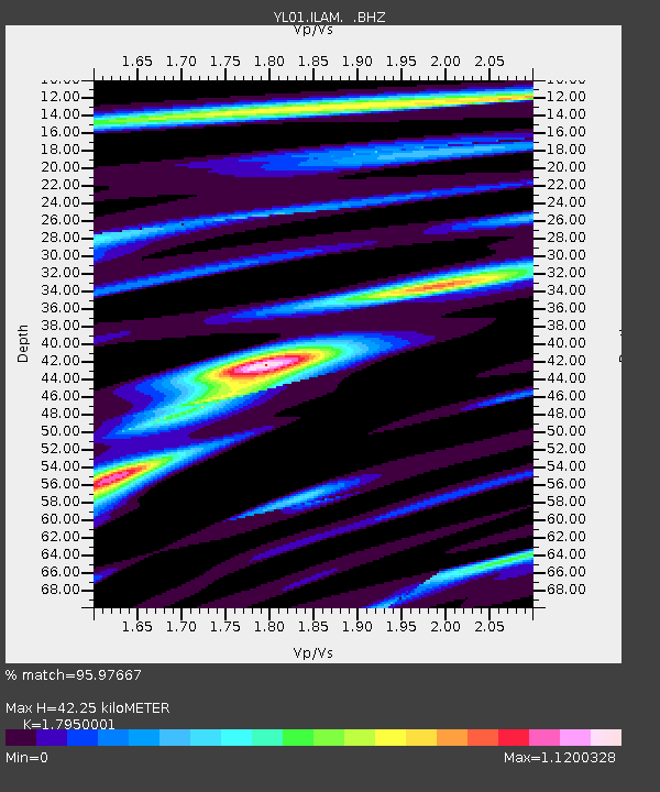
ILAM YL.ILAM - Earthquake Result Viewer
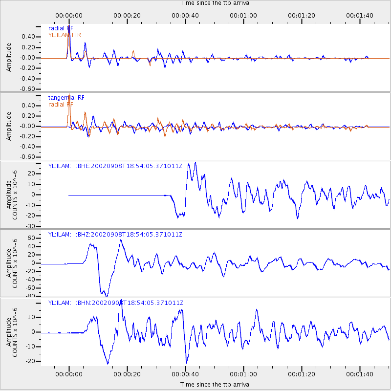
Earthquake location: Near N Coast Of New Guinea, P.N.G.
Earthquake latitude/longitude: -3.3/142.9
Earthquake time(UTC): 2002/09/08 (251) 18:44:23 GMT
Earthquake Depth: 13 km
Earthquake Magnitude: 6.5 MB, 7.8 MS, 7.6 MW, 7.3 MW
Earthquake Catalog/Contributor: WHDF/NEIC
Network: YL Himalayan Nepal Tibet Experiment
Station: ILAM YL.ILAM
Lat/Lon: 26.91 N/87.92 E
Elevation: 1181 m
Distance: 61.0 deg
Az: 303.197 deg
Baz: 110.677 deg
Ray Param: 0.061174784
Estimated Moho Depth: 42.25 km
Estimated Crust Vp/Vs: 1.80
Assumed Crust Vp: 6.236 km/s
Estimated Crust Vs: 3.474 km/s
Estimated Crust Poisson's Ratio: 0.27
Radial Match: 95.97667 %
Radial Bump: 400
Transverse Match: 94.47719 %
Transverse Bump: 400
SOD ConfigId: 16844
Insert Time: 2010-02-26 15:56:49.969 +0000
GWidth: 2.5
Max Bumps: 400
Tol: 0.001

Signal To Noise

ChannelStoNSTALTA
YL:ILAM: :BHZ:20020908T18:54:05.371011Z4.4831775.4244583E-71.2099585E-7
YL:ILAM: :BHN:20020908T18:54:05.371011Z1.55280539.644522E-86.211031E-8
YL:ILAM: :BHE:20020908T18:54:05.371011Z3.1315842.0529941E-76.555769E-8
Arrivals
Ps5.6 SECOND
PpPs18 SECOND
PsPs/PpSs24 SECOND