You are here: Home > Network List > YL01 - Himalayan Nepal Tibet Experiment Stations List
> Station ILAM YL.ILAM > Earthquake Result Viewer
ILAM YL.ILAM - Earthquake Result Viewer
| Earthquake location: |
Northeastern China |
| Earthquake latitude/longitude: |
44.8/129.9 |
| Earthquake time(UTC): |
2002/09/15 (258) 08:39:32 GMT |
| Earthquake Depth: |
586 km |
| Earthquake Magnitude: |
5.8 MB, 6.4 MW, 6.4 MW |
| Earthquake Catalog/Contributor: |
WHDF/NEIC |
|
| Network: |
YL Himalayan Nepal Tibet Experiment |
| Station: |
ILAM YL.ILAM |
| Lat/Lon: |
26.91 N/87.92 E |
| Elevation: |
1181 m |
|
| Distance: |
38.0 deg |
| Az: |
256.273 deg |
| Baz: |
50.722 deg |
| Ray Param: |
0.07282916 |
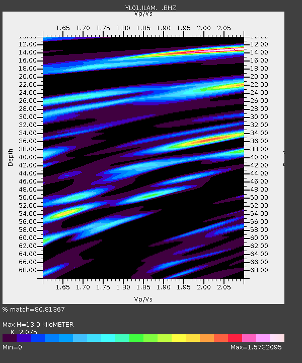
| Estimated Moho Depth: |
13.0 km |
| Estimated Crust Vp/Vs: |
2.08 |
| Assumed Crust Vp: |
6.236 km/s |
| Estimated Crust Vs: |
3.005 km/s |
| Estimated Crust Poisson's Ratio: |
0.35 |
|
| Radial Match: |
80.81367 % |
| Radial Bump: |
400 |
| Transverse Match: |
75.525215 % |
| Transverse Bump: |
400 |
| SOD ConfigId: |
16844 |
| Insert Time: |
2010-02-26 15:56:51.767 +0000 |
| GWidth: |
2.5 |
| Max Bumps: |
400 |
| Tol: |
0.001 |
|
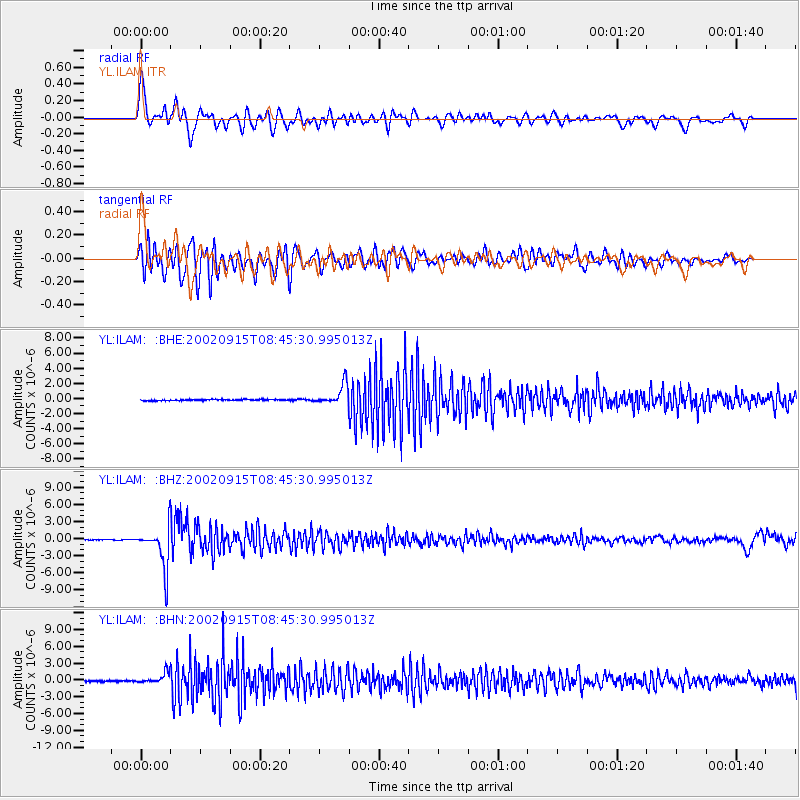
Signal To Noise
| Channel | StoN | STA | LTA |
| YL:ILAM: :BHZ:20020915T08:45:30.995013Z | 63.07408 | 3.6020258E-6 | 5.710786E-8 |
| YL:ILAM: :BHN:20020915T08:45:30.995013Z | 8.505428 | 9.432494E-7 | 1.108997E-7 |
| YL:ILAM: :BHE:20020915T08:45:30.995013Z | 18.120438 | 1.3305397E-6 | 7.3427564E-8 |
| Arrivals |
| Ps | 2.4 SECOND |
| PpPs | 6.1 SECOND |
| PsPs/PpSs | 8.4 SECOND |


