You are here: Home > Network List > YL01 - Himalayan Nepal Tibet Experiment Stations List
> Station ILAM YL.ILAM > Earthquake Result Viewer
ILAM YL.ILAM - Earthquake Result Viewer
| Earthquake location: |
Bali Sea |
| Earthquake latitude/longitude: |
-7.5/115.7 |
| Earthquake time(UTC): |
2002/10/03 (276) 19:05:10 GMT |
| Earthquake Depth: |
316 km |
| Earthquake Magnitude: |
6.0 MB, 6.0 MW, 6.0 MW |
| Earthquake Catalog/Contributor: |
WHDF/NEIC |
|
| Network: |
YL Himalayan Nepal Tibet Experiment |
| Station: |
ILAM YL.ILAM |
| Lat/Lon: |
26.91 N/87.92 E |
| Elevation: |
1181 m |
|
| Distance: |
43.5 deg |
| Az: |
322.881 deg |
| Baz: |
137.926 deg |
| Ray Param: |
0.071159534 |
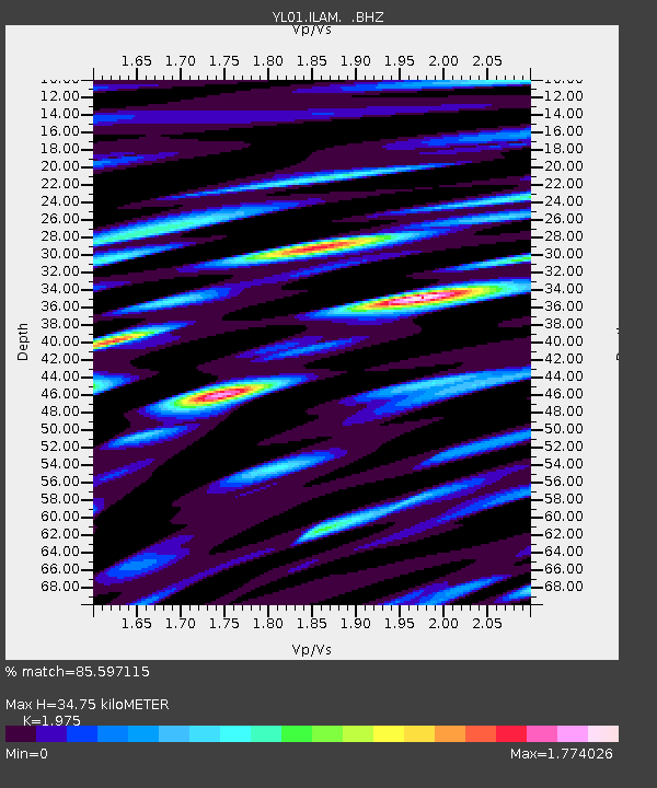
| Estimated Moho Depth: |
34.75 km |
| Estimated Crust Vp/Vs: |
1.98 |
| Assumed Crust Vp: |
6.236 km/s |
| Estimated Crust Vs: |
3.157 km/s |
| Estimated Crust Poisson's Ratio: |
0.33 |
|
| Radial Match: |
85.597115 % |
| Radial Bump: |
400 |
| Transverse Match: |
79.163086 % |
| Transverse Bump: |
400 |
| SOD ConfigId: |
16844 |
| Insert Time: |
2010-02-26 15:56:53.902 +0000 |
| GWidth: |
2.5 |
| Max Bumps: |
400 |
| Tol: |
0.001 |
|
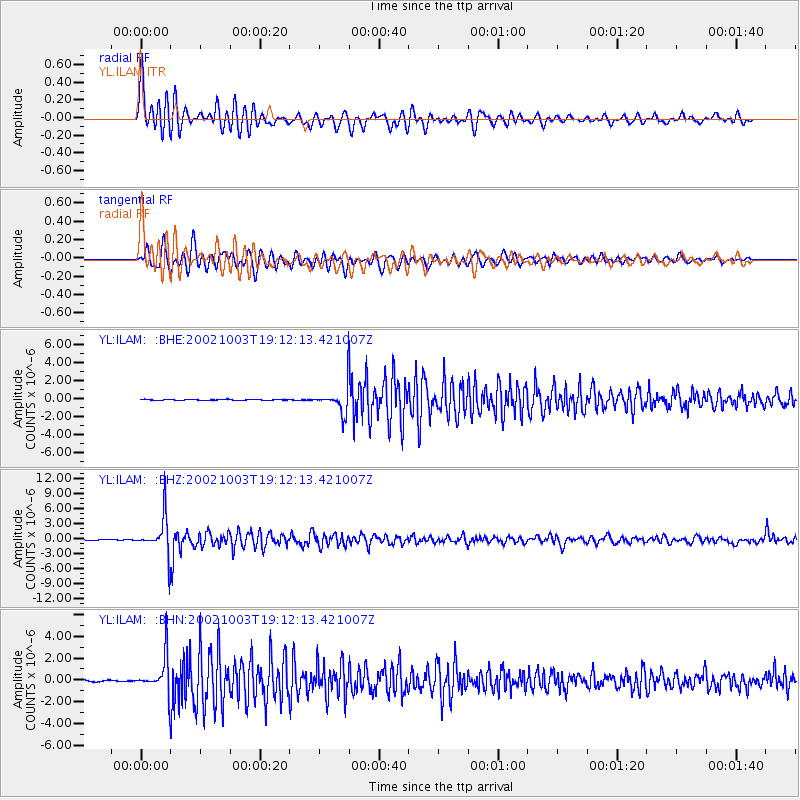
Signal To Noise
| Channel | StoN | STA | LTA |
| YL:ILAM: :BHZ:20021003T19:12:13.421007Z | 56.03788 | 3.7204347E-6 | 6.639143E-8 |
| YL:ILAM: :BHN:20021003T19:12:13.421007Z | 24.751345 | 1.633372E-6 | 6.5991244E-8 |
| YL:ILAM: :BHE:20021003T19:12:13.421007Z | 27.406673 | 1.4029946E-6 | 5.1191712E-8 |
| Arrivals |
| Ps | 5.7 SECOND |
| PpPs | 16 SECOND |
| PsPs/PpSs | 21 SECOND |


