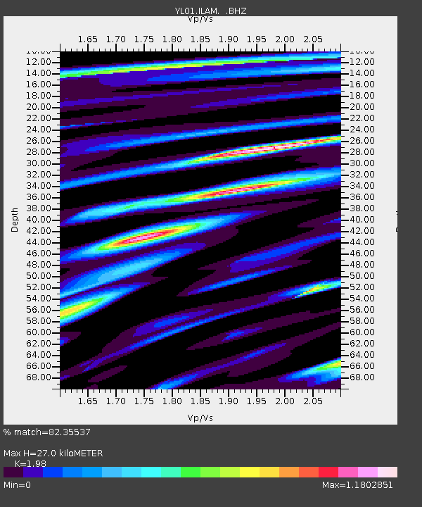
ILAM YL.ILAM - Earthquake Result Viewer
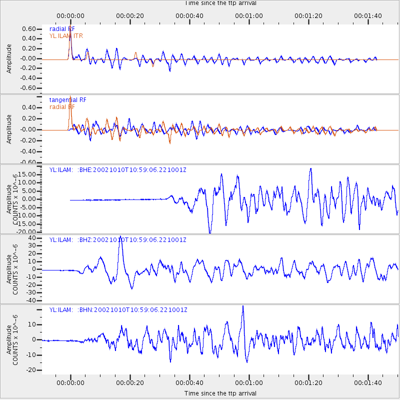
Earthquake location: Irian Jaya Region, Indonesia
Earthquake latitude/longitude: -1.8/134.3
Earthquake time(UTC): 2002/10/10 (283) 10:50:20 GMT
Earthquake Depth: 10 km
Earthquake Magnitude: 6.5 MB, 7.7 MS, 7.6 MW, 7.4 MW
Earthquake Catalog/Contributor: WHDF/NEIC
Network: YL Himalayan Nepal Tibet Experiment
Station: ILAM YL.ILAM
Lat/Lon: 26.91 N/87.92 E
Elevation: 1181 m
Distance: 53.0 deg
Az: 305.949 deg
Baz: 115.017 deg
Ray Param: 0.066406526
Estimated Moho Depth: 27.0 km
Estimated Crust Vp/Vs: 1.98
Assumed Crust Vp: 6.236 km/s
Estimated Crust Vs: 3.149 km/s
Estimated Crust Poisson's Ratio: 0.33
Radial Match: 82.35537 %
Radial Bump: 400
Transverse Match: 80.14338 %
Transverse Bump: 400
SOD ConfigId: 16844
Insert Time: 2010-02-26 15:56:55.737 +0000
GWidth: 2.5
Max Bumps: 400
Tol: 0.001

Signal To Noise

ChannelStoNSTALTA
YL:ILAM: :BHZ:20021010T10:59:06.221001Z13.1811762.14532E-61.6275635E-7
YL:ILAM: :BHN:20021010T10:59:06.221001Z4.5825445.871257E-71.2812224E-7
YL:ILAM: :BHE:20021010T10:59:06.221001Z7.71328741.1142893E-61.444636E-7
Arrivals
Ps4.4 SECOND
PpPs12 SECOND
PsPs/PpSs17 SECOND