You are here: Home > Network List > YL01 - Himalayan Nepal Tibet Experiment Stations List
> Station ILAM YL.ILAM > Earthquake Result Viewer
ILAM YL.ILAM - Earthquake Result Viewer
| Earthquake location: |
Hokkaido, Japan Region |
| Earthquake latitude/longitude: |
41.2/142.2 |
| Earthquake time(UTC): |
2002/10/14 (287) 14:12:43 GMT |
| Earthquake Depth: |
61 km |
| Earthquake Magnitude: |
5.9 MB, 6.1 MW, 6.1 MW |
| Earthquake Catalog/Contributor: |
WHDF/NEIC |
|
| Network: |
YL Himalayan Nepal Tibet Experiment |
| Station: |
ILAM YL.ILAM |
| Lat/Lon: |
26.91 N/87.92 E |
| Elevation: |
1181 m |
|
| Distance: |
46.5 deg |
| Az: |
269.868 deg |
| Baz: |
57.716 deg |
| Ray Param: |
0.07042987 |
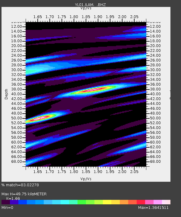
| Estimated Moho Depth: |
49.75 km |
| Estimated Crust Vp/Vs: |
1.66 |
| Assumed Crust Vp: |
6.236 km/s |
| Estimated Crust Vs: |
3.757 km/s |
| Estimated Crust Poisson's Ratio: |
0.22 |
|
| Radial Match: |
83.02278 % |
| Radial Bump: |
400 |
| Transverse Match: |
79.30669 % |
| Transverse Bump: |
400 |
| SOD ConfigId: |
16844 |
| Insert Time: |
2010-02-26 15:56:57.166 +0000 |
| GWidth: |
2.5 |
| Max Bumps: |
400 |
| Tol: |
0.001 |
|
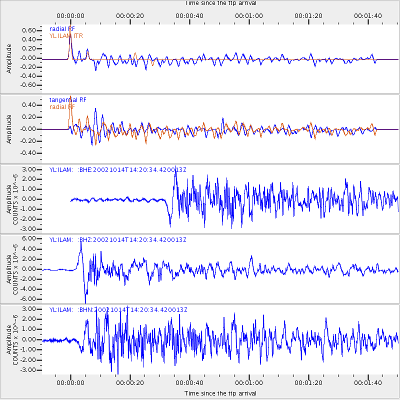
Signal To Noise
| Channel | StoN | STA | LTA |
| YL:ILAM: :BHZ:20021014T14:20:34.420013Z | 26.6753 | 2.0502698E-6 | 7.686023E-8 |
| YL:ILAM: :BHN:20021014T14:20:34.420013Z | 5.3229713 | 4.8658023E-7 | 9.1411394E-8 |
| YL:ILAM: :BHE:20021014T14:20:34.420013Z | 10.702503 | 9.719571E-7 | 9.081587E-8 |
| Arrivals |
| Ps | 5.6 SECOND |
| PpPs | 20 SECOND |
| PsPs/PpSs | 26 SECOND |


