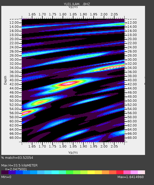
ILAM YL.ILAM - Earthquake Result Viewer
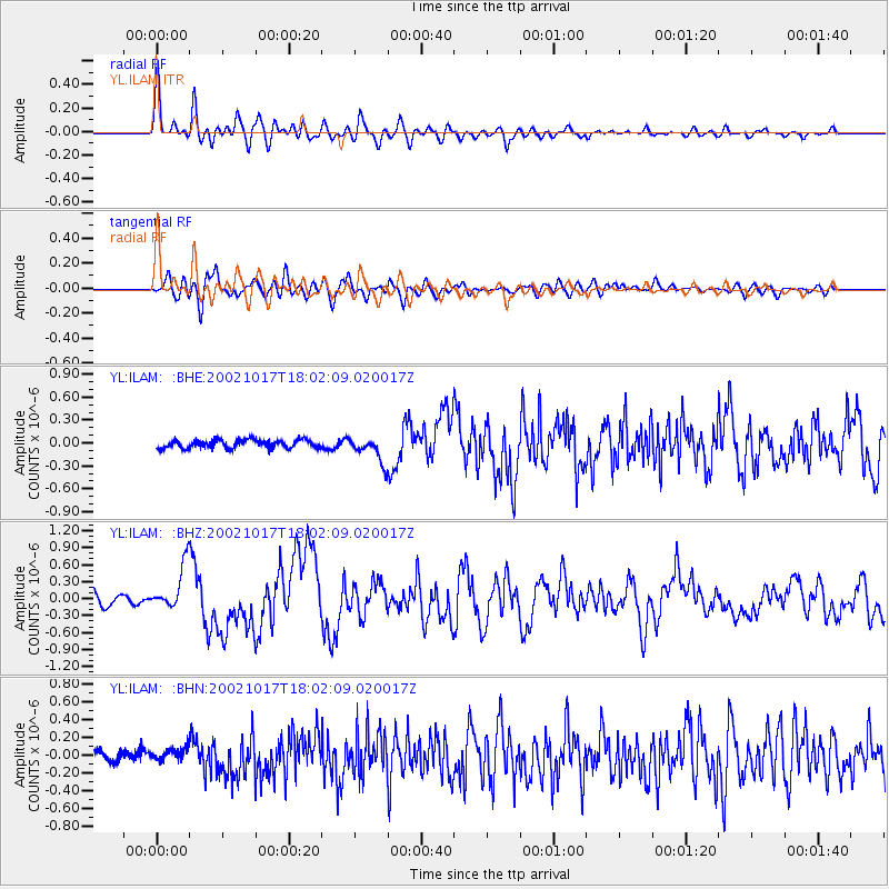
Earthquake location: Irian Jaya, Indonesia
Earthquake latitude/longitude: -3.6/140.2
Earthquake time(UTC): 2002/10/17 (290) 17:52:44 GMT
Earthquake Depth: 33 km
Earthquake Magnitude: 5.6 MB, 6.2 MS, 6.3 MW, 6.3 MW
Earthquake Catalog/Contributor: WHDF/NEIC
Network: YL Himalayan Nepal Tibet Experiment
Station: ILAM YL.ILAM
Lat/Lon: 26.91 N/87.92 E
Elevation: 1181 m
Distance: 58.9 deg
Az: 304.375 deg
Baz: 112.703 deg
Ray Param: 0.062502086
Estimated Moho Depth: 33.5 km
Estimated Crust Vp/Vs: 2.05
Assumed Crust Vp: 6.236 km/s
Estimated Crust Vs: 3.046 km/s
Estimated Crust Poisson's Ratio: 0.34
Radial Match: 83.52054 %
Radial Bump: 400
Transverse Match: 77.54604 %
Transverse Bump: 400
SOD ConfigId: 16844
Insert Time: 2010-02-26 15:56:59.020 +0000
GWidth: 2.5
Max Bumps: 400
Tol: 0.001

Signal To Noise

ChannelStoNSTALTA
YL:ILAM: :BHZ:20021017T18:02:09.020017Z5.3399643.8973258E-77.298412E-8
YL:ILAM: :BHN:20021017T18:02:09.020017Z1.24041077.189709E-85.7962332E-8
YL:ILAM: :BHE:20021017T18:02:09.020017Z3.10854361.6491639E-75.305262E-8
Arrivals
Ps5.9 SECOND
PpPs16 SECOND
PsPs/PpSs22 SECOND