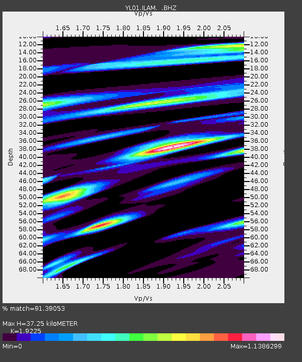
ILAM YL.ILAM - Earthquake Result Viewer
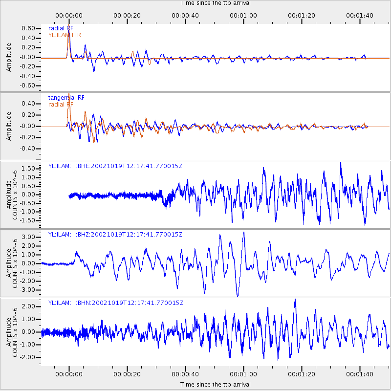
Earthquake location: Kuril Islands
Earthquake latitude/longitude: 44.3/150.0
Earthquake time(UTC): 2002/10/19 (292) 12:09:05 GMT
Earthquake Depth: 33 km
Earthquake Magnitude: 5.4 MB, 6.2 MS, 6.4 MW, 6.1 MW
Earthquake Catalog/Contributor: WHDF/NEIC
Network: YL Himalayan Nepal Tibet Experiment
Station: ILAM YL.ILAM
Lat/Lon: 26.91 N/87.92 E
Elevation: 1181 m
Distance: 52.1 deg
Az: 272.313 deg
Baz: 53.467 deg
Ray Param: 0.06689999
Estimated Moho Depth: 37.25 km
Estimated Crust Vp/Vs: 1.92
Assumed Crust Vp: 6.236 km/s
Estimated Crust Vs: 3.244 km/s
Estimated Crust Poisson's Ratio: 0.31
Radial Match: 91.39053 %
Radial Bump: 400
Transverse Match: 90.080246 %
Transverse Bump: 400
SOD ConfigId: 16844
Insert Time: 2010-02-26 15:57:01.006 +0000
GWidth: 2.5
Max Bumps: 400
Tol: 0.001

Signal To Noise

ChannelStoNSTALTA
YL:ILAM: :BHZ:20021019T12:17:41.770015Z8.5817145.933535E-76.914161E-8
YL:ILAM: :BHN:20021019T12:17:41.770015Z2.1496023.0301376E-71.4096274E-7
YL:ILAM: :BHE:20021019T12:17:41.770015Z3.46548632.9897495E-78.627215E-8
Arrivals
Ps5.8 SECOND
PpPs17 SECOND
PsPs/PpSs22 SECOND