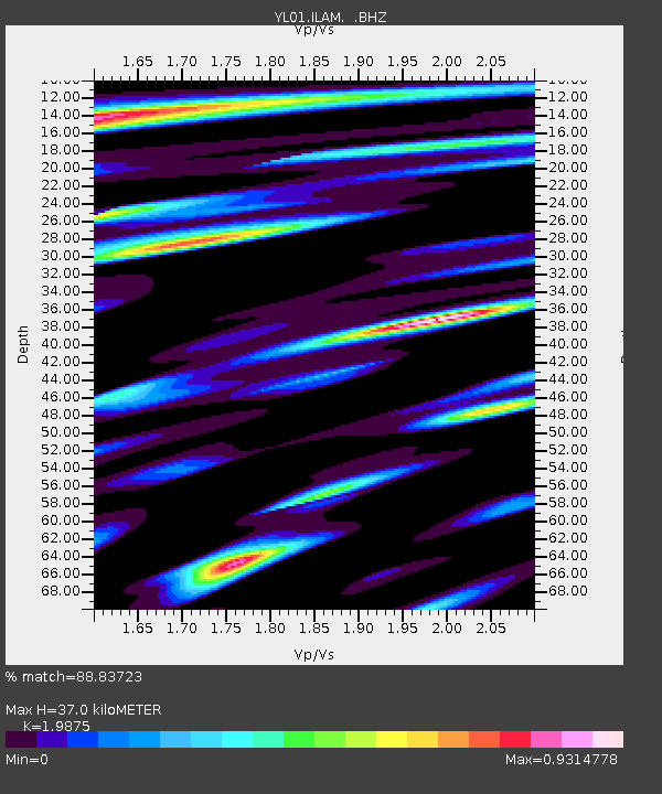
ILAM YL.ILAM - Earthquake Result Viewer
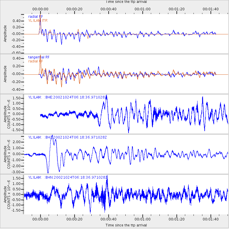
Earthquake location: Lake Tanganyika Region
Earthquake latitude/longitude: -1.9/29.0
Earthquake time(UTC): 2002/10/24 (297) 06:08:37 GMT
Earthquake Depth: 11 km
Earthquake Magnitude: 5.9 MB, 6.3 MS, 6.2 MW, 6.1 MW
Earthquake Catalog/Contributor: WHDF/NEIC
Network: YL Himalayan Nepal Tibet Experiment
Station: ILAM YL.ILAM
Lat/Lon: 26.91 N/87.92 E
Elevation: 1181 m
Distance: 63.5 deg
Az: 58.699 deg
Baz: 253.016 deg
Ray Param: 0.05952799
Estimated Moho Depth: 37.0 km
Estimated Crust Vp/Vs: 1.99
Assumed Crust Vp: 6.236 km/s
Estimated Crust Vs: 3.138 km/s
Estimated Crust Poisson's Ratio: 0.33
Radial Match: 88.83723 %
Radial Bump: 400
Transverse Match: 87.16506 %
Transverse Bump: 400
SOD ConfigId: 16844
Insert Time: 2010-02-26 15:57:02.603 +0000
GWidth: 2.5
Max Bumps: 400
Tol: 0.001

Signal To Noise

ChannelStoNSTALTA
YL:ILAM: :BHZ:20021024T06:18:36.971028Z14.1130061.1875278E-68.414421E-8
YL:ILAM: :BHN:20021024T06:18:36.971028Z1.79683273.095215E-71.7225952E-7
YL:ILAM: :BHE:20021024T06:18:36.971028Z2.7725664.0779688E-71.4708284E-7
Arrivals
Ps6.1 SECOND
PpPs17 SECOND
PsPs/PpSs23 SECOND