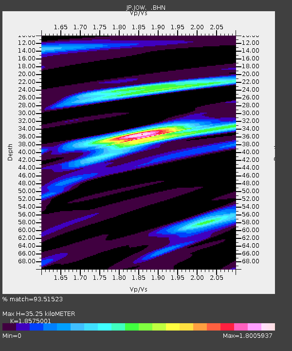
JOW Okinawa Kunigami - Earthquake Result Viewer

Earthquake location: Off W Coast Of Northern Sumatra
Earthquake latitude/longitude: 2.8/96.0
Earthquake time(UTC): 2008/02/20 (051) 08:08:30 GMT
Earthquake Depth: 26 km
Earthquake Magnitude: 6.5 MB, 7.5 MS, 7.4 MW, 7.4 MW
Earthquake Catalog/Contributor: WHDF/NEIC
Network: JP Japan Meteorological Agency Seismic Network
Station: JOW Okinawa Kunigami
Lat/Lon: 26.84 N/128.27 E
Elevation: 220 m
Distance: 39.1 deg
Az: 49.196 deg
Baz: 237.798 deg
Ray Param: 0.07512663
Estimated Moho Depth: 35.25 km
Estimated Crust Vp/Vs: 1.86
Assumed Crust Vp: 6.183 km/s
Estimated Crust Vs: 3.328 km/s
Estimated Crust Poisson's Ratio: 0.30
Radial Match: 93.51523 %
Radial Bump: 400
Transverse Match: 83.87142 %
Transverse Bump: 400
SOD ConfigId: 2564
Insert Time: 2010-03-09 12:20:34.049 +0000
GWidth: 2.5
Max Bumps: 400
Tol: 0.001

Signal To Noise

ChannelStoNSTALTA
JP:JOW: :BHN:20080220T08:15:25.048015Z1.14911949.209861E-78.014712E-7
JP:JOW: :BHE:20080220T08:15:25.048015Z5.0882372.7773992E-65.458471E-7
JP:JOW: :BHZ:20080220T08:15:25.048015Z6.87113863.9981624E-65.8187766E-7
Arrivals
Ps5.2 SECOND
PpPs15 SECOND
PsPs/PpSs21 SECOND