You are here: Home > Network List > GS - US Geological Survey Networks Stations List
> Station OK051 E0350 and S34600 Roads, Ralston, OK > Earthquake Result Viewer
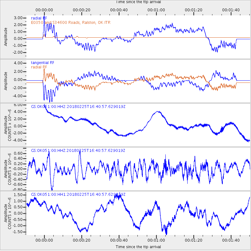
OK051 E0350 and S34600 Roads, Ralston, OK - Earthquake Result Viewer
*The percent match for this event was below the threshold and hence no stack was calculated.
| Earthquake location: |
Near East Coast Of Honshu, Japan |
| Earthquake latitude/longitude: |
37.6/141.7 |
| Earthquake time(UTC): |
2018/02/25 (056) 16:28:39 GMT |
| Earthquake Depth: |
31 km |
| Earthquake Magnitude: |
5.6 Mww |
| Earthquake Catalog/Contributor: |
NEIC PDE/us |
|
| Network: |
GS US Geological Survey Networks |
| Station: |
OK051 E0350 and S34600 Roads, Ralston, OK |
| Lat/Lon: |
36.51 N/96.84 W |
| Elevation: |
263 m |
|
| Distance: |
88.5 deg |
| Az: |
43.457 deg |
| Baz: |
317.302 deg |
| Ray Param: |
$rayparam |
*The percent match for this event was below the threshold and hence was not used in the summary stack. |
|
| Radial Match: |
59.300953 % |
| Radial Bump: |
400 |
| Transverse Match: |
67.737915 % |
| Transverse Bump: |
400 |
| SOD ConfigId: |
2546091 |
| Insert Time: |
2018-03-11 16:30:17.681 +0000 |
| GWidth: |
2.5 |
| Max Bumps: |
400 |
| Tol: |
0.001 |
|
Signal To Noise
| Channel | StoN | STA | LTA |
| GS:OK051:00:HHZ:20180225T16:40:57.629019Z | 1.5879955 | 4.373911E-7 | 2.7543595E-7 |
| GS:OK051:00:HH1:20180225T16:40:57.629019Z | 1.1068524 | 1.200677E-6 | 1.0847671E-6 |
| GS:OK051:00:HH2:20180225T16:40:57.629019Z | 3.4736676 | 3.4786258E-6 | 1.0014274E-6 |
| Arrivals |
| Ps | |
| PpPs | |
| PsPs/PpSs | |


