You are here: Home > Network List > IW - Intermountain West Stations List
> Station MOOW Moose Ponds, Wyoming, USA > Earthquake Result Viewer
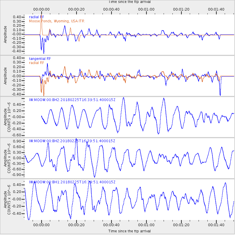
MOOW Moose Ponds, Wyoming, USA - Earthquake Result Viewer
*The percent match for this event was below the threshold and hence no stack was calculated.
| Earthquake location: |
Near East Coast Of Honshu, Japan |
| Earthquake latitude/longitude: |
37.6/141.7 |
| Earthquake time(UTC): |
2018/02/25 (056) 16:28:39 GMT |
| Earthquake Depth: |
31 km |
| Earthquake Magnitude: |
5.6 Mww |
| Earthquake Catalog/Contributor: |
NEIC PDE/us |
|
| Network: |
IW Intermountain West |
| Station: |
MOOW Moose Ponds, Wyoming, USA |
| Lat/Lon: |
43.75 N/110.74 W |
| Elevation: |
2128 m |
|
| Distance: |
75.8 deg |
| Az: |
45.472 deg |
| Baz: |
308.607 deg |
| Ray Param: |
$rayparam |
*The percent match for this event was below the threshold and hence was not used in the summary stack. |
|
| Radial Match: |
77.634384 % |
| Radial Bump: |
339 |
| Transverse Match: |
57.83772 % |
| Transverse Bump: |
400 |
| SOD ConfigId: |
2546091 |
| Insert Time: |
2018-03-11 16:31:03.786 +0000 |
| GWidth: |
2.5 |
| Max Bumps: |
400 |
| Tol: |
0.001 |
|
Signal To Noise
| Channel | StoN | STA | LTA |
| IW:MOOW:00:BHZ:20180225T16:39:51.400015Z | 2.759227 | 4.0122848E-7 | 1.4541335E-7 |
| IW:MOOW:00:BH1:20180225T16:39:51.400015Z | 1.0185628 | 2.893851E-7 | 2.8411122E-7 |
| IW:MOOW:00:BH2:20180225T16:39:51.400015Z | 0.91681194 | 1.9547849E-7 | 2.1321547E-7 |
| Arrivals |
| Ps | |
| PpPs | |
| PsPs/PpSs | |


