You are here: Home > Network List > US - United States National Seismic Network Stations List
> Station DGMT Dagmar, Montana, USA > Earthquake Result Viewer
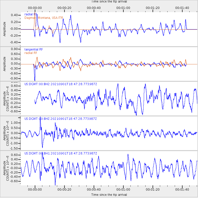
DGMT Dagmar, Montana, USA - Earthquake Result Viewer
*The percent match for this event was below the threshold and hence no stack was calculated.
| Earthquake location: |
Near Coast Of Northern Chile |
| Earthquake latitude/longitude: |
-27.7/-71.2 |
| Earthquake time(UTC): |
2021/09/01 (244) 18:35:44 GMT |
| Earthquake Depth: |
17 km |
| Earthquake Magnitude: |
5.8 mww |
| Earthquake Catalog/Contributor: |
NEIC PDE/us |
|
| Network: |
US United States National Seismic Network |
| Station: |
DGMT Dagmar, Montana, USA |
| Lat/Lon: |
48.47 N/104.20 W |
| Elevation: |
0.0 m |
|
| Distance: |
81.4 deg |
| Az: |
338.502 deg |
| Baz: |
150.785 deg |
| Ray Param: |
$rayparam |
*The percent match for this event was below the threshold and hence was not used in the summary stack. |
|
| Radial Match: |
57.958797 % |
| Radial Bump: |
400 |
| Transverse Match: |
67.52073 % |
| Transverse Bump: |
376 |
| SOD ConfigId: |
25131211 |
| Insert Time: |
2021-09-15 18:55:22.939 +0000 |
| GWidth: |
2.5 |
| Max Bumps: |
400 |
| Tol: |
0.001 |
|
Signal To Noise
| Channel | StoN | STA | LTA |
| US:DGMT:00:BHZ:20210901T18:47:28.773987Z | 2.8715606 | 4.658959E-7 | 1.6224485E-7 |
| US:DGMT:00:BH1:20210901T18:47:28.773987Z | 1.2207259 | 2.4388177E-7 | 1.9978422E-7 |
| US:DGMT:00:BH2:20210901T18:47:28.773987Z | 0.99736613 | 1.7655564E-7 | 1.7702189E-7 |
| Arrivals |
| Ps | |
| PpPs | |
| PsPs/PpSs | |


