You are here: Home > Network List > IU - Global Seismograph Network (GSN - IRIS/USGS) Stations List
> Station NWAO Narrogin, Australia > Earthquake Result Viewer
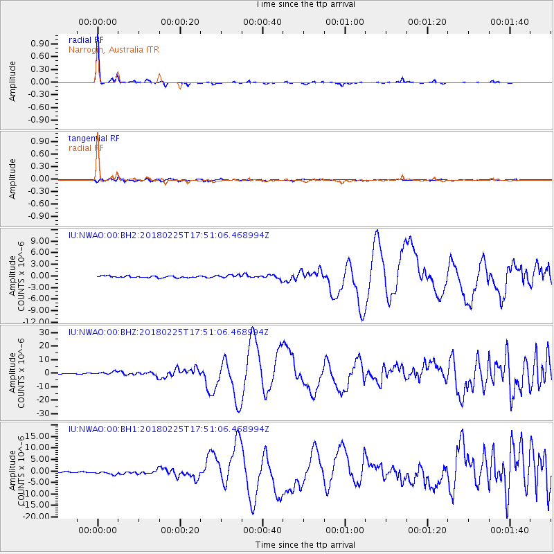
NWAO Narrogin, Australia - Earthquake Result Viewer

| Earthquake location: |
New Guinea, Papua New Guinea |
| Earthquake latitude/longitude: |
-6.2/142.8 |
| Earthquake time(UTC): |
2018/02/25 (056) 17:44:39 GMT |
| Earthquake Depth: |
10 km |
| Earthquake Magnitude: |
7.6 Mi |
| Earthquake Catalog/Contributor: |
NEIC PDE/at |
|
| Network: |
IU Global Seismograph Network (GSN - IRIS/USGS) |
| Station: |
NWAO Narrogin, Australia |
| Lat/Lon: |
32.93 S/117.24 E |
| Elevation: |
380 m |
|
| Distance: |
35.7 deg |
| Az: |
218.482 deg |
| Baz: |
47.361 deg |
| Ray Param: |
0.07709724 |
| Estimated Moho Depth: |
26.5 km |
| Estimated Crust Vp/Vs: |
2.08 |
| Assumed Crust Vp: |
6.419 km/s |
| Estimated Crust Vs: |
3.09 km/s |
| Estimated Crust Poisson's Ratio: |
0.35 |
|
| Radial Match: |
96.75342 % |
| Radial Bump: |
151 |
| Transverse Match: |
87.448105 % |
| Transverse Bump: |
379 |
| SOD ConfigId: |
2546091 |
| Insert Time: |
2018-03-11 17:45:55.600 +0000 |
| GWidth: |
2.5 |
| Max Bumps: |
400 |
| Tol: |
0.001 |
|
Signal To Noise
| Channel | StoN | STA | LTA |
| IU:NWAO:00:BHZ:20180225T17:51:06.468994Z | 3.9928815 | 1.0974525E-6 | 2.7485223E-7 |
| IU:NWAO:00:BH1:20180225T17:51:06.468994Z | 3.3808746 | 7.245292E-7 | 2.1430229E-7 |
| IU:NWAO:00:BH2:20180225T17:51:06.468994Z | 1.8256881 | 3.9772175E-7 | 2.1784757E-7 |
| Arrivals |
| Ps | 4.7 SECOND |
| PpPs | 12 SECOND |
| PsPs/PpSs | 17 SECOND |


