You are here: Home > Network List > IU - Global Seismograph Network (GSN - IRIS/USGS) Stations List
> Station SNZO South Karori, New Zealand > Earthquake Result Viewer
SNZO South Karori, New Zealand - Earthquake Result Viewer
| Earthquake location: |
New Guinea, Papua New Guinea |
| Earthquake latitude/longitude: |
-6.2/142.8 |
| Earthquake time(UTC): |
2018/02/25 (056) 17:44:39 GMT |
| Earthquake Depth: |
10 km |
| Earthquake Magnitude: |
7.6 Mi |
| Earthquake Catalog/Contributor: |
NEIC PDE/at |
|
| Network: |
IU Global Seismograph Network (GSN - IRIS/USGS) |
| Station: |
SNZO South Karori, New Zealand |
| Lat/Lon: |
41.31 S/174.70 E |
| Elevation: |
120 m |
|
| Distance: |
45.1 deg |
| Az: |
145.77 deg |
| Baz: |
312.066 deg |
| Ray Param: |
0.07152998 |
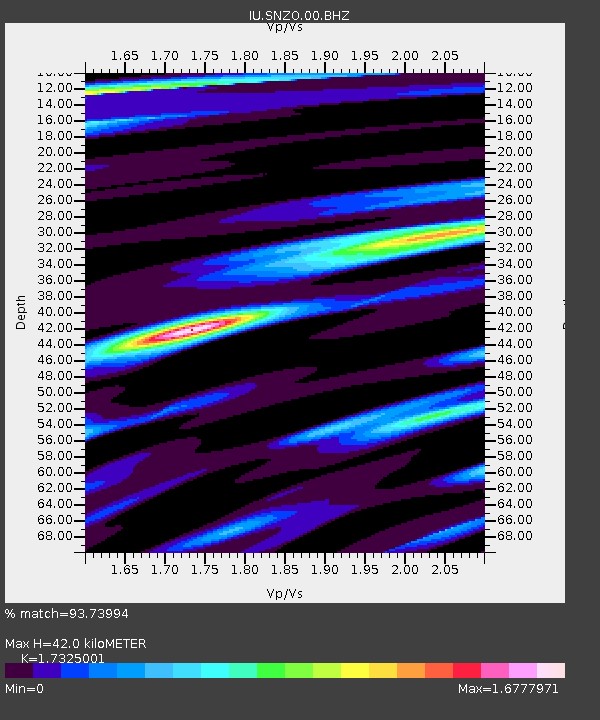
| Estimated Moho Depth: |
42.0 km |
| Estimated Crust Vp/Vs: |
1.73 |
| Assumed Crust Vp: |
6.461 km/s |
| Estimated Crust Vs: |
3.73 km/s |
| Estimated Crust Poisson's Ratio: |
0.25 |
|
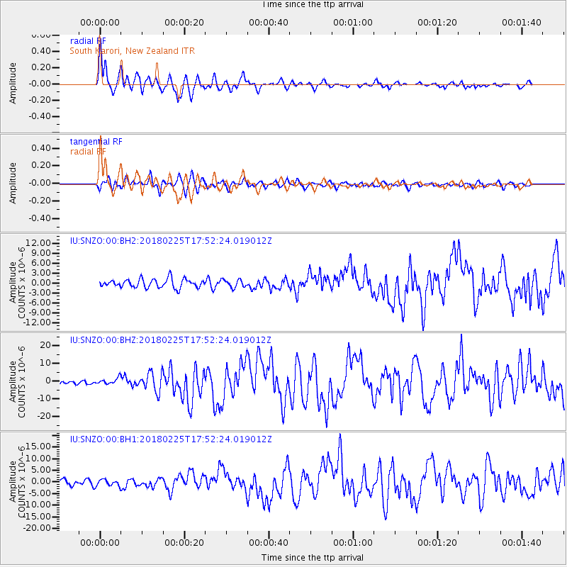
| Radial Match: |
93.73994 % |
| Radial Bump: |
400 |
| Transverse Match: |
78.17282 % |
| Transverse Bump: |
400 |
| SOD ConfigId: |
2546091 |
| Insert Time: |
2018-03-11 17:46:03.690 +0000 |
| GWidth: |
2.5 |
| Max Bumps: |
400 |
| Tol: |
0.001 |
|
Signal To Noise
| Channel | StoN | STA | LTA |
| IU:SNZO:00:BHZ:20180225T17:52:24.019012Z | 2.5489419 | 1.921663E-6 | 7.539062E-7 |
| IU:SNZO:00:BH1:20180225T17:52:24.019012Z | 1.0303901 | 1.3031566E-6 | 1.2647215E-6 |
| IU:SNZO:00:BH2:20180225T17:52:24.019012Z | 0.92266387 | 1.1930341E-6 | 1.2930323E-6 |
| Arrivals |
| Ps | 5.1 SECOND |
| PpPs | 17 SECOND |
| PsPs/PpSs | 22 SECOND |


