You are here: Home > Network List > IW - Intermountain West Stations List
> Station MOOW Moose Ponds, Wyoming, USA > Earthquake Result Viewer
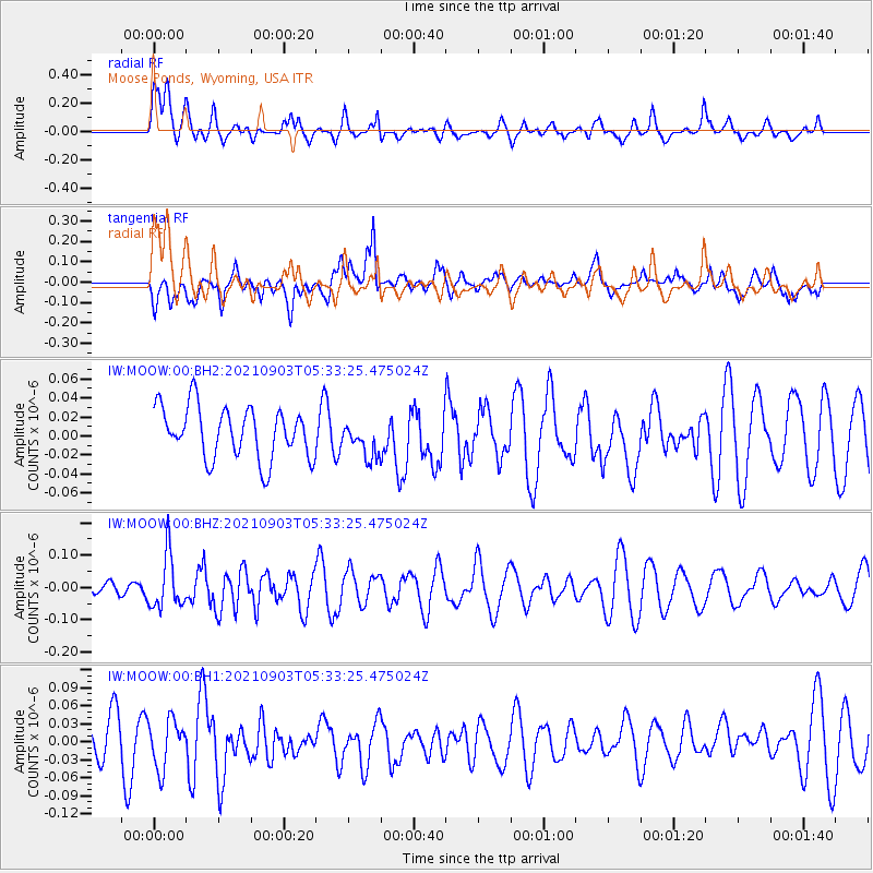
MOOW Moose Ponds, Wyoming, USA - Earthquake Result Viewer
*The percent match for this event was below the threshold and hence no stack was calculated.
| Earthquake location: |
Southern East Pacific Rise |
| Earthquake latitude/longitude: |
-24.3/-116.0 |
| Earthquake time(UTC): |
2021/09/03 (246) 05:22:58 GMT |
| Earthquake Depth: |
10 km |
| Earthquake Magnitude: |
5.4 Mww |
| Earthquake Catalog/Contributor: |
NEIC PDE/us |
|
| Network: |
IW Intermountain West |
| Station: |
MOOW Moose Ponds, Wyoming, USA |
| Lat/Lon: |
43.75 N/110.74 W |
| Elevation: |
2128 m |
|
| Distance: |
67.9 deg |
| Az: |
4.086 deg |
| Baz: |
185.147 deg |
| Ray Param: |
$rayparam |
*The percent match for this event was below the threshold and hence was not used in the summary stack. |
|
| Radial Match: |
57.479122 % |
| Radial Bump: |
399 |
| Transverse Match: |
64.35342 % |
| Transverse Bump: |
400 |
| SOD ConfigId: |
25131211 |
| Insert Time: |
2021-09-17 05:34:04.879 +0000 |
| GWidth: |
2.5 |
| Max Bumps: |
400 |
| Tol: |
0.001 |
|
Signal To Noise
| Channel | StoN | STA | LTA |
| IW:MOOW:00:BHZ:20210903T05:33:25.475024Z | 3.8706913 | 8.31882E-8 | 2.1491818E-8 |
| IW:MOOW:00:BH1:20210903T05:33:25.475024Z | 0.8426911 | 4.0237683E-8 | 4.774903E-8 |
| IW:MOOW:00:BH2:20210903T05:33:25.475024Z | 0.6923286 | 1.8815241E-8 | 2.7176752E-8 |
| Arrivals |
| Ps | |
| PpPs | |
| PsPs/PpSs | |


