You are here: Home > Network List > TA - USArray Transportable Network (new EarthScope stations) Stations List
> Station POKR Poker Plat Research Range, AK, USA > Earthquake Result Viewer
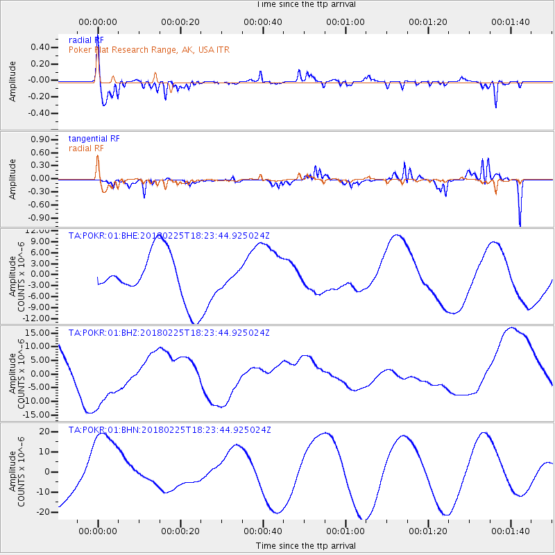
POKR Poker Plat Research Range, AK, USA - Earthquake Result Viewer
*The percent match for this event was below the threshold and hence no stack was calculated.
| Earthquake location: |
New Guinea, Papua New Guinea |
| Earthquake latitude/longitude: |
-5.8/142.2 |
| Earthquake time(UTC): |
2018/02/25 (056) 18:11:34 GMT |
| Earthquake Depth: |
39 km |
| Earthquake Magnitude: |
5.5 mb |
| Earthquake Catalog/Contributor: |
NEIC PDE/us |
|
| Network: |
TA USArray Transportable Network (new EarthScope stations) |
| Station: |
POKR Poker Plat Research Range, AK, USA |
| Lat/Lon: |
65.12 N/147.43 W |
| Elevation: |
501 m |
|
| Distance: |
87.1 deg |
| Az: |
23.51 deg |
| Baz: |
249.743 deg |
| Ray Param: |
$rayparam |
*The percent match for this event was below the threshold and hence was not used in the summary stack. |
|
| Radial Match: |
69.96174 % |
| Radial Bump: |
316 |
| Transverse Match: |
60.998596 % |
| Transverse Bump: |
284 |
| SOD ConfigId: |
2546091 |
| Insert Time: |
2018-03-11 18:12:58.825 +0000 |
| GWidth: |
2.5 |
| Max Bumps: |
400 |
| Tol: |
0.001 |
|
Signal To Noise
| Channel | StoN | STA | LTA |
| TA:POKR:01:BHZ:20180225T18:23:44.925024Z | 2.5991516 | 1.2172256E-5 | 4.683165E-6 |
| TA:POKR:01:BHN:20180225T18:23:44.925024Z | 2.3041096 | 2.0773343E-5 | 9.015779E-6 |
| TA:POKR:01:BHE:20180225T18:23:44.925024Z | 0.305321 | 2.032997E-6 | 6.6585553E-6 |
| Arrivals |
| Ps | |
| PpPs | |
| PsPs/PpSs | |


