You are here: Home > Network List > US - United States National Seismic Network Stations List
> Station MSO Missoula, Montana, USA > Earthquake Result Viewer
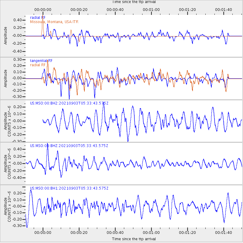
MSO Missoula, Montana, USA - Earthquake Result Viewer
*The percent match for this event was below the threshold and hence no stack was calculated.
| Earthquake location: |
Southern East Pacific Rise |
| Earthquake latitude/longitude: |
-24.3/-116.0 |
| Earthquake time(UTC): |
2021/09/03 (246) 05:22:58 GMT |
| Earthquake Depth: |
10 km |
| Earthquake Magnitude: |
5.4 Mww |
| Earthquake Catalog/Contributor: |
NEIC PDE/us |
|
| Network: |
US United States National Seismic Network |
| Station: |
MSO Missoula, Montana, USA |
| Lat/Lon: |
46.83 N/113.94 W |
| Elevation: |
1264 m |
|
| Distance: |
70.8 deg |
| Az: |
1.475 deg |
| Baz: |
181.961 deg |
| Ray Param: |
$rayparam |
*The percent match for this event was below the threshold and hence was not used in the summary stack. |
|
| Radial Match: |
61.67622 % |
| Radial Bump: |
400 |
| Transverse Match: |
51.463337 % |
| Transverse Bump: |
396 |
| SOD ConfigId: |
25131211 |
| Insert Time: |
2021-09-17 05:42:19.222 +0000 |
| GWidth: |
2.5 |
| Max Bumps: |
400 |
| Tol: |
0.001 |
|
Signal To Noise
| Channel | StoN | STA | LTA |
| US:MSO:00:BHZ:20210903T05:33:43.575Z | 1.6699187 | 2.093252E-7 | 1.2535052E-7 |
| US:MSO:00:BH1:20210903T05:33:43.575Z | 0.4653193 | 6.693515E-8 | 1.4384779E-7 |
| US:MSO:00:BH2:20210903T05:33:43.575Z | 1.9587548 | 1.4664776E-7 | 7.4867856E-8 |
| Arrivals |
| Ps | |
| PpPs | |
| PsPs/PpSs | |


