You are here: Home > Network List > UW - Pacific Northwest Regional Seismic Network Stations List
> Station UMAT Pilot Rock, OR, USA > Earthquake Result Viewer
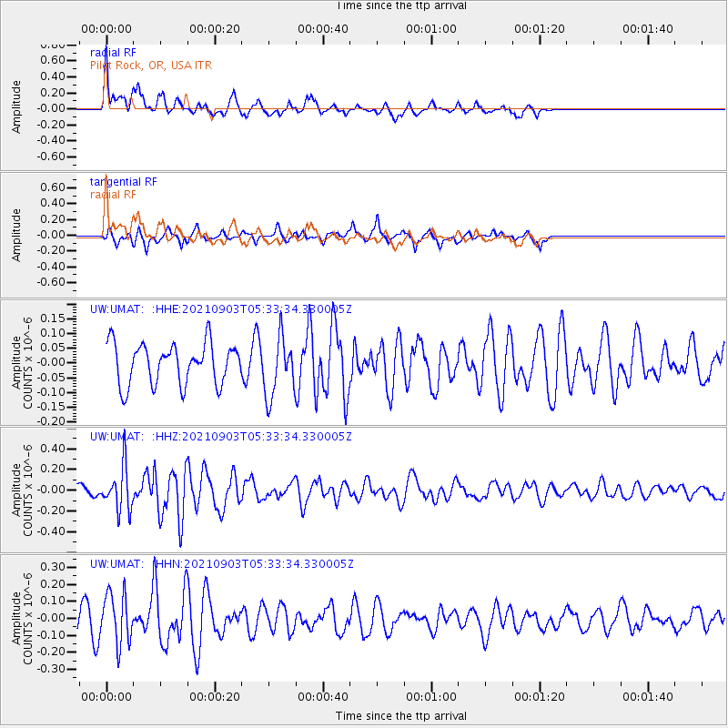
UMAT Pilot Rock, OR, USA - Earthquake Result Viewer
*The percent match for this event was below the threshold and hence no stack was calculated.
| Earthquake location: |
Southern East Pacific Rise |
| Earthquake latitude/longitude: |
-24.3/-116.0 |
| Earthquake time(UTC): |
2021/09/03 (246) 05:22:58 GMT |
| Earthquake Depth: |
10 km |
| Earthquake Magnitude: |
5.4 Mww |
| Earthquake Catalog/Contributor: |
NEIC PDE/us |
|
| Network: |
UW Pacific Northwest Regional Seismic Network |
| Station: |
UMAT Pilot Rock, OR, USA |
| Lat/Lon: |
45.29 N/118.96 W |
| Elevation: |
1318 m |
|
| Distance: |
69.3 deg |
| Az: |
357.745 deg |
| Baz: |
177.084 deg |
| Ray Param: |
$rayparam |
*The percent match for this event was below the threshold and hence was not used in the summary stack. |
|
| Radial Match: |
60.631893 % |
| Radial Bump: |
400 |
| Transverse Match: |
52.131035 % |
| Transverse Bump: |
295 |
| SOD ConfigId: |
25131211 |
| Insert Time: |
2021-09-17 05:44:05.729 +0000 |
| GWidth: |
2.5 |
| Max Bumps: |
400 |
| Tol: |
0.001 |
|
Signal To Noise
| Channel | StoN | STA | LTA |
| UW:UMAT: :HHZ:20210903T05:33:34.330005Z | 3.3429868 | 2.1248498E-7 | 6.3561416E-8 |
| UW:UMAT: :HHN:20210903T05:33:34.330005Z | 2.1089458 | 1.4816433E-7 | 7.025516E-8 |
| UW:UMAT: :HHE:20210903T05:33:34.330005Z | 1.4646386 | 1.0127354E-7 | 6.9145756E-8 |
| Arrivals |
| Ps | |
| PpPs | |
| PsPs/PpSs | |


