You are here: Home > Network List > AV - Alaska Volcano Observatory Stations List
> Station CAHL Cahill, Katmai, Alaska > Earthquake Result Viewer
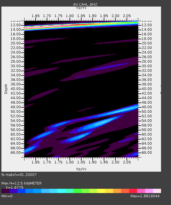
CAHL Cahill, Katmai, Alaska - Earthquake Result Viewer
| Earthquake location: |
Sea Of Okhotsk |
| Earthquake latitude/longitude: |
49.5/147.0 |
| Earthquake time(UTC): |
2021/09/03 (246) 10:14:26 GMT |
| Earthquake Depth: |
582 km |
| Earthquake Magnitude: |
5.8 Mww |
| Earthquake Catalog/Contributor: |
NEIC PDE/us |
|
| Network: |
AV Alaska Volcano Observatory |
| Station: |
CAHL Cahill, Katmai, Alaska |
| Lat/Lon: |
58.05 N/155.30 W |
| Elevation: |
807 m |
|
| Distance: |
34.2 deg |
| Az: |
53.124 deg |
| Baz: |
281.066 deg |
| Ray Param: |
0.07496907 |
| Estimated Moho Depth: |
12.5 km |
| Estimated Crust Vp/Vs: |
1.68 |
| Assumed Crust Vp: |
6.438 km/s |
| Estimated Crust Vs: |
3.838 km/s |
| Estimated Crust Poisson's Ratio: |
0.22 |
|
| Radial Match: |
81.20007 % |
| Radial Bump: |
400 |
| Transverse Match: |
73.407234 % |
| Transverse Bump: |
400 |
| SOD ConfigId: |
25131211 |
| Insert Time: |
2021-09-17 10:20:29.047 +0000 |
| GWidth: |
2.5 |
| Max Bumps: |
400 |
| Tol: |
0.001 |
|

Signal To Noise
| Channel | StoN | STA | LTA |
| AV:CAHL: :BHZ:20210903T10:19:53.99999Z | 3.4220672 | 1.0309859E-6 | 3.0127578E-7 |
| AV:CAHL: :BHN:20210903T10:19:53.99999Z | 2.5586612 | 8.339445E-7 | 3.2593005E-7 |
| AV:CAHL: :BHE:20210903T10:19:53.99999Z | 3.0140142 | 8.2985974E-7 | 2.7533372E-7 |
| Arrivals |
| Ps | 1.4 SECOND |
| PpPs | 4.8 SECOND |
| PsPs/PpSs | 6.2 SECOND |


