You are here: Home > Network List > C8 - Canadian Seismic Research Network () Stations List
> Station GRIB Gribbell Island, BC, CA > Earthquake Result Viewer
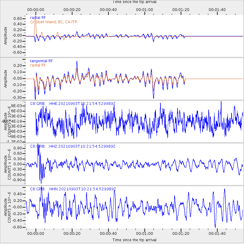
GRIB Gribbell Island, BC, CA - Earthquake Result Viewer
*The percent match for this event was below the threshold and hence no stack was calculated.
| Earthquake location: |
Sea Of Okhotsk |
| Earthquake latitude/longitude: |
49.5/147.0 |
| Earthquake time(UTC): |
2021/09/03 (246) 10:14:26 GMT |
| Earthquake Depth: |
582 km |
| Earthquake Magnitude: |
5.8 Mww |
| Earthquake Catalog/Contributor: |
NEIC PDE/us |
|
| Network: |
C8 Canadian Seismic Research Network () |
| Station: |
GRIB Gribbell Island, BC, CA |
| Lat/Lon: |
53.34 N/129.14 W |
| Elevation: |
418 m |
|
| Distance: |
49.6 deg |
| Az: |
51.544 deg |
| Baz: |
301.585 deg |
| Ray Param: |
$rayparam |
*The percent match for this event was below the threshold and hence was not used in the summary stack. |
|
| Radial Match: |
49.35746 % |
| Radial Bump: |
400 |
| Transverse Match: |
48.863583 % |
| Transverse Bump: |
400 |
| SOD ConfigId: |
25131211 |
| Insert Time: |
2021-09-17 10:22:51.053 +0000 |
| GWidth: |
2.5 |
| Max Bumps: |
400 |
| Tol: |
0.001 |
|
Signal To Noise
| Channel | StoN | STA | LTA |
| C8:GRIB: :HHZ:20210903T10:21:54.529989Z | 3.8535807 | 5.353938E-7 | 1.3893411E-7 |
| C8:GRIB: :HHN:20210903T10:21:54.529989Z | 1.6895844 | 2.54366E-7 | 1.5054945E-7 |
| C8:GRIB: :HHE:20210903T10:21:54.529989Z | 0.80292743 | 3.3182412E-9 | 4.132679E-9 |
| Arrivals |
| Ps | |
| PpPs | |
| PsPs/PpSs | |


