You are here: Home > Network List > IU - Global Seismograph Network (GSN - IRIS/USGS) Stations List
> Station JOHN Johnston Island, USA > Earthquake Result Viewer
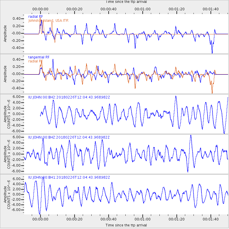
JOHN Johnston Island, USA - Earthquake Result Viewer
*The percent match for this event was below the threshold and hence no stack was calculated.
| Earthquake location: |
New Guinea, Papua New Guinea |
| Earthquake latitude/longitude: |
-6.5/143.6 |
| Earthquake time(UTC): |
2018/02/26 (057) 11:56:07 GMT |
| Earthquake Depth: |
13 km |
| Earthquake Magnitude: |
5.7 Mww |
| Earthquake Catalog/Contributor: |
NEIC PDE/us |
|
| Network: |
IU Global Seismograph Network (GSN - IRIS/USGS) |
| Station: |
JOHN Johnston Island, USA |
| Lat/Lon: |
16.73 N/169.53 W |
| Elevation: |
2.0 m |
|
| Distance: |
51.8 deg |
| Az: |
62.912 deg |
| Baz: |
247.408 deg |
| Ray Param: |
$rayparam |
*The percent match for this event was below the threshold and hence was not used in the summary stack. |
|
| Radial Match: |
66.789085 % |
| Radial Bump: |
349 |
| Transverse Match: |
52.242306 % |
| Transverse Bump: |
400 |
| SOD ConfigId: |
2546091 |
| Insert Time: |
2018-03-12 11:58:35.822 +0000 |
| GWidth: |
2.5 |
| Max Bumps: |
400 |
| Tol: |
0.001 |
|
Signal To Noise
| Channel | StoN | STA | LTA |
| IU:JOHN:00:BHZ:20180226T12:04:43.968982Z | 1.7628012 | 2.7667372E-6 | 1.5695118E-6 |
| IU:JOHN:00:BH1:20180226T12:04:43.968982Z | 2.6827414 | 5.0284084E-6 | 1.8743544E-6 |
| IU:JOHN:00:BH2:20180226T12:04:43.968982Z | 0.5482835 | 1.1549555E-6 | 2.1064932E-6 |
| Arrivals |
| Ps | |
| PpPs | |
| PsPs/PpSs | |


