You are here: Home > Network List > US - United States National Seismic Network Stations List
> Station DUG Dugway, Tooele County, Utah, USA > Earthquake Result Viewer
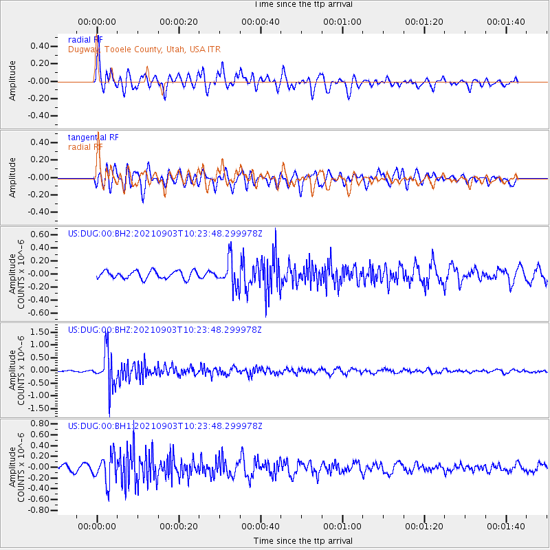
DUG Dugway, Tooele County, Utah, USA - Earthquake Result Viewer
*The percent match for this event was below the threshold and hence no stack was calculated.
| Earthquake location: |
Sea Of Okhotsk |
| Earthquake latitude/longitude: |
49.5/147.0 |
| Earthquake time(UTC): |
2021/09/03 (246) 10:14:26 GMT |
| Earthquake Depth: |
582 km |
| Earthquake Magnitude: |
5.8 Mww |
| Earthquake Catalog/Contributor: |
NEIC PDE/us |
|
| Network: |
US United States National Seismic Network |
| Station: |
DUG Dugway, Tooele County, Utah, USA |
| Lat/Lon: |
40.19 N/112.81 W |
| Elevation: |
1477 m |
|
| Distance: |
66.5 deg |
| Az: |
55.293 deg |
| Baz: |
315.565 deg |
| Ray Param: |
$rayparam |
*The percent match for this event was below the threshold and hence was not used in the summary stack. |
|
| Radial Match: |
76.44144 % |
| Radial Bump: |
400 |
| Transverse Match: |
70.29471 % |
| Transverse Bump: |
400 |
| SOD ConfigId: |
25131211 |
| Insert Time: |
2021-09-17 10:45:13.567 +0000 |
| GWidth: |
2.5 |
| Max Bumps: |
400 |
| Tol: |
0.001 |
|
Signal To Noise
| Channel | StoN | STA | LTA |
| US:DUG:00:BHZ:20210903T10:23:48.299978Z | 12.638389 | 7.0214253E-7 | 5.5556335E-8 |
| US:DUG:00:BH1:20210903T10:23:48.299978Z | 5.162475 | 2.6253923E-7 | 5.0855302E-8 |
| US:DUG:00:BH2:20210903T10:23:48.299978Z | 3.665617 | 2.1684106E-7 | 5.9155408E-8 |
| Arrivals |
| Ps | |
| PpPs | |
| PsPs/PpSs | |


