You are here: Home > Network List > US - United States National Seismic Network Stations List
> Station LKWY Lake (Yellowstone--Lake), Wyoming, USA > Earthquake Result Viewer
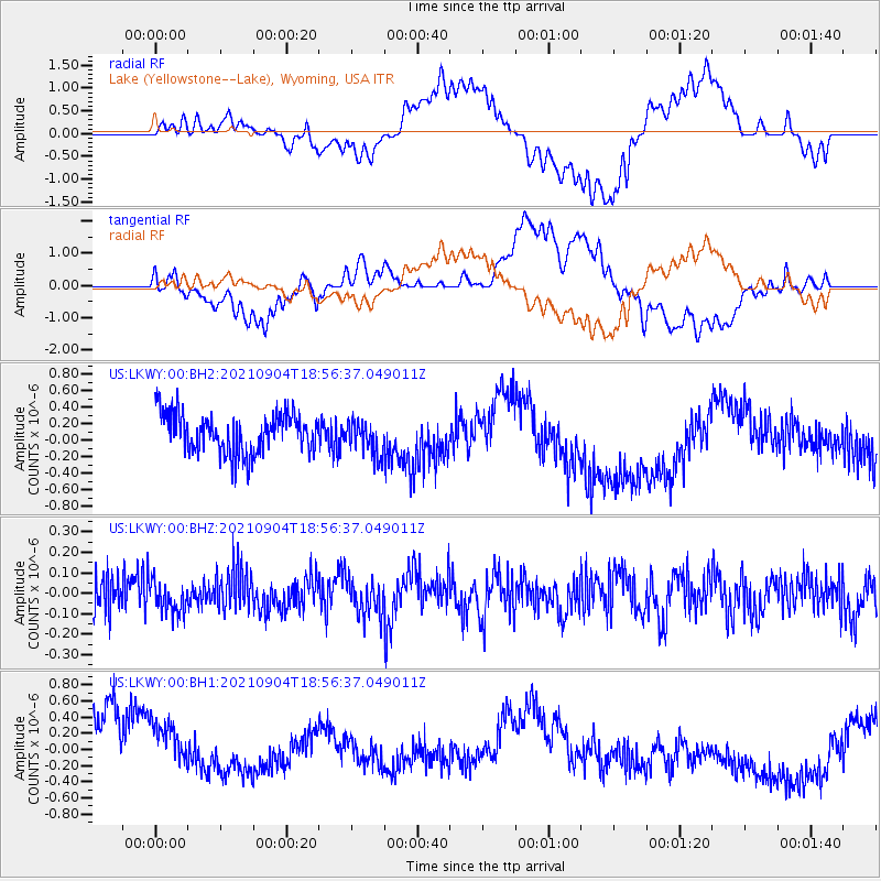
LKWY Lake (Yellowstone--Lake), Wyoming, USA - Earthquake Result Viewer
*The percent match for this event was below the threshold and hence no stack was calculated.
| Earthquake location: |
Solomon Islands |
| Earthquake latitude/longitude: |
-6.4/154.9 |
| Earthquake time(UTC): |
2021/09/04 (247) 18:43:39 GMT |
| Earthquake Depth: |
60 km |
| Earthquake Magnitude: |
5.4 Mww |
| Earthquake Catalog/Contributor: |
NEIC PDE/us |
|
| Network: |
US United States National Seismic Network |
| Station: |
LKWY Lake (Yellowstone--Lake), Wyoming, USA |
| Lat/Lon: |
44.57 N/110.40 W |
| Elevation: |
2424 m |
|
| Distance: |
97.8 deg |
| Az: |
45.975 deg |
| Baz: |
268.709 deg |
| Ray Param: |
$rayparam |
*The percent match for this event was below the threshold and hence was not used in the summary stack. |
|
| Radial Match: |
42.85249 % |
| Radial Bump: |
400 |
| Transverse Match: |
41.13787 % |
| Transverse Bump: |
400 |
| SOD ConfigId: |
25131211 |
| Insert Time: |
2021-09-18 18:57:44.017 +0000 |
| GWidth: |
2.5 |
| Max Bumps: |
400 |
| Tol: |
0.001 |
|
Signal To Noise
| Channel | StoN | STA | LTA |
| US:LKWY:00:BHZ:20210904T18:56:37.049011Z | 0.87641734 | 7.604786E-8 | 8.677129E-8 |
| US:LKWY:00:BH1:20210904T18:56:37.049011Z | 0.7979797 | 5.1792813E-7 | 6.490493E-7 |
| US:LKWY:00:BH2:20210904T18:56:37.049011Z | 0.86879915 | 2.0918299E-7 | 2.4077255E-7 |
| Arrivals |
| Ps | |
| PpPs | |
| PsPs/PpSs | |


