You are here: Home > Network List > AU - Australian Seismological Centre Stations List
> Station PSAB1 Pilbara Seismic Array Element B1 > Earthquake Result Viewer
PSAB1 Pilbara Seismic Array Element B1 - Earthquake Result Viewer
| Earthquake location: |
West Of Macquarie Island |
| Earthquake latitude/longitude: |
-60.2/150.8 |
| Earthquake time(UTC): |
2018/02/27 (058) 17:29:22 GMT |
| Earthquake Depth: |
10 km |
| Earthquake Magnitude: |
6.1 Mww |
| Earthquake Catalog/Contributor: |
NEIC PDE/us |
|
| Network: |
AU Australian Seismological Centre |
| Station: |
PSAB1 Pilbara Seismic Array Element B1 |
| Lat/Lon: |
21.57 S/119.82 E |
| Elevation: |
317 m |
|
| Distance: |
44.4 deg |
| Az: |
316.793 deg |
| Baz: |
158.479 deg |
| Ray Param: |
0.07196317 |
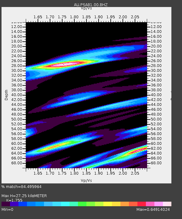
| Estimated Moho Depth: |
27.25 km |
| Estimated Crust Vp/Vs: |
1.75 |
| Assumed Crust Vp: |
6.464 km/s |
| Estimated Crust Vs: |
3.683 km/s |
| Estimated Crust Poisson's Ratio: |
0.26 |
|
| Radial Match: |
84.495964 % |
| Radial Bump: |
341 |
| Transverse Match: |
69.46822 % |
| Transverse Bump: |
400 |
| SOD ConfigId: |
2546091 |
| Insert Time: |
2018-03-13 17:29:55.391 +0000 |
| GWidth: |
2.5 |
| Max Bumps: |
400 |
| Tol: |
0.001 |
|

Signal To Noise
| Channel | StoN | STA | LTA |
| AU:PSAB1:00:BHZ:20180227T17:37:02.069004Z | 1.4703969 | 8.4069006E-7 | 5.717436E-7 |
| AU:PSAB1:00:BH1:20180227T17:37:02.069004Z | 1.2255707 | 2.8521524E-7 | 2.3272032E-7 |
| AU:PSAB1:00:BH2:20180227T17:37:02.069004Z | 2.5590541 | 4.4495386E-7 | 1.7387434E-7 |
| Arrivals |
| Ps | 3.4 SECOND |
| PpPs | 11 SECOND |
| PsPs/PpSs | 14 SECOND |


