You are here: Home > Network List > AU - Australian Seismological Centre Stations List
> Station PSAD3 Pilbara Seismic Array Element D3 > Earthquake Result Viewer
PSAD3 Pilbara Seismic Array Element D3 - Earthquake Result Viewer
| Earthquake location: |
West Of Macquarie Island |
| Earthquake latitude/longitude: |
-60.2/150.8 |
| Earthquake time(UTC): |
2018/02/27 (058) 17:29:22 GMT |
| Earthquake Depth: |
10 km |
| Earthquake Magnitude: |
6.1 Mww |
| Earthquake Catalog/Contributor: |
NEIC PDE/us |
|
| Network: |
AU Australian Seismological Centre |
| Station: |
PSAD3 Pilbara Seismic Array Element D3 |
| Lat/Lon: |
21.64 S/119.78 E |
| Elevation: |
327 m |
|
| Distance: |
44.3 deg |
| Az: |
316.702 deg |
| Baz: |
158.43 deg |
| Ray Param: |
0.07199653 |
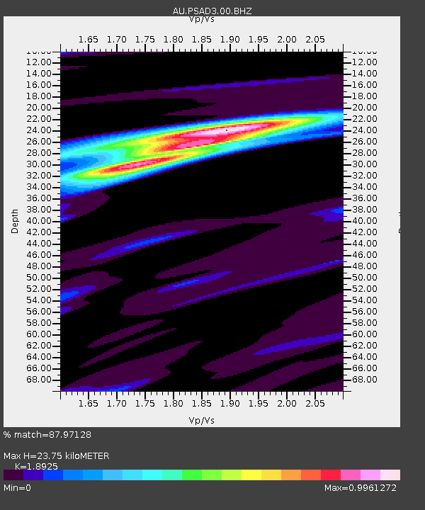
| Estimated Moho Depth: |
23.75 km |
| Estimated Crust Vp/Vs: |
1.89 |
| Assumed Crust Vp: |
6.464 km/s |
| Estimated Crust Vs: |
3.415 km/s |
| Estimated Crust Poisson's Ratio: |
0.31 |
|
| Radial Match: |
87.97128 % |
| Radial Bump: |
279 |
| Transverse Match: |
62.995373 % |
| Transverse Bump: |
400 |
| SOD ConfigId: |
2546091 |
| Insert Time: |
2018-03-13 17:30:07.188 +0000 |
| GWidth: |
2.5 |
| Max Bumps: |
400 |
| Tol: |
0.001 |
|

Signal To Noise
| Channel | StoN | STA | LTA |
| AU:PSAD3:00:BHZ:20180227T17:37:01.643986Z | 2.003364 | 9.390186E-7 | 4.687209E-7 |
| AU:PSAD3:00:BH1:20180227T17:37:01.643986Z | 2.3475158 | 4.9024806E-7 | 2.0883697E-7 |
| AU:PSAD3:00:BH2:20180227T17:37:01.643986Z | 0.7630569 | 2.0742866E-7 | 2.7183904E-7 |
| Arrivals |
| Ps | 3.5 SECOND |
| PpPs | 10.0 SECOND |
| PsPs/PpSs | 13 SECOND |


