You are here: Home > Network List > AK - Alaska Regional Network Stations List
> Station CCB Clear Creek Butte > Earthquake Result Viewer
CCB Clear Creek Butte - Earthquake Result Viewer
| Earthquake location: |
Tonga Islands Region |
| Earthquake latitude/longitude: |
-22.1/-174.2 |
| Earthquake time(UTC): |
2021/09/05 (248) 17:51:42 GMT |
| Earthquake Depth: |
10 km |
| Earthquake Magnitude: |
5.9 mww |
| Earthquake Catalog/Contributor: |
NEIC PDE/us |
|
| Network: |
AK Alaska Regional Network |
| Station: |
CCB Clear Creek Butte |
| Lat/Lon: |
64.65 N/147.80 W |
| Elevation: |
248 m |
|
| Distance: |
88.8 deg |
| Az: |
11.025 deg |
| Baz: |
204.327 deg |
| Ray Param: |
0.042290483 |
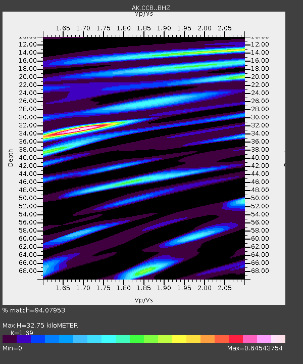
| Estimated Moho Depth: |
32.75 km |
| Estimated Crust Vp/Vs: |
1.69 |
| Assumed Crust Vp: |
6.566 km/s |
| Estimated Crust Vs: |
3.885 km/s |
| Estimated Crust Poisson's Ratio: |
0.23 |
|
| Radial Match: |
94.07953 % |
| Radial Bump: |
322 |
| Transverse Match: |
91.26042 % |
| Transverse Bump: |
342 |
| SOD ConfigId: |
25131211 |
| Insert Time: |
2021-09-19 17:52:53.882 +0000 |
| GWidth: |
2.5 |
| Max Bumps: |
400 |
| Tol: |
0.001 |
|

Signal To Noise
| Channel | StoN | STA | LTA |
| AK:CCB: :BHZ:20210905T18:04:04.927985Z | 22.896965 | 1.1439996E-6 | 4.996294E-8 |
| AK:CCB: :BHN:20210905T18:04:04.927985Z | 5.7897267 | 2.508339E-7 | 4.332396E-8 |
| AK:CCB: :BHE:20210905T18:04:04.927985Z | 4.560246 | 2.0173661E-7 | 4.42381E-8 |
| Arrivals |
| Ps | 3.5 SECOND |
| PpPs | 13 SECOND |
| PsPs/PpSs | 17 SECOND |


