You are here: Home > Network List > AK - Alaska Regional Network Stations List
> Station SLK Skilak Lake, AK, USA > Earthquake Result Viewer
SLK Skilak Lake, AK, USA - Earthquake Result Viewer
| Earthquake location: |
Tonga Islands Region |
| Earthquake latitude/longitude: |
-22.1/-174.2 |
| Earthquake time(UTC): |
2021/09/05 (248) 17:51:42 GMT |
| Earthquake Depth: |
10 km |
| Earthquake Magnitude: |
5.9 mww |
| Earthquake Catalog/Contributor: |
NEIC PDE/us |
|
| Network: |
AK Alaska Regional Network |
| Station: |
SLK Skilak Lake, AK, USA |
| Lat/Lon: |
60.51 N/150.22 W |
| Elevation: |
655 m |
|
| Distance: |
84.6 deg |
| Az: |
11.636 deg |
| Baz: |
202.215 deg |
| Ray Param: |
0.045385856 |
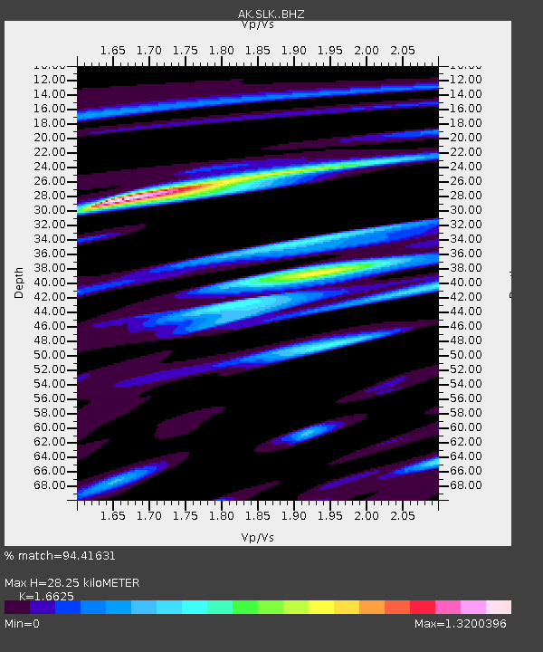
| Estimated Moho Depth: |
28.25 km |
| Estimated Crust Vp/Vs: |
1.66 |
| Assumed Crust Vp: |
6.302 km/s |
| Estimated Crust Vs: |
3.79 km/s |
| Estimated Crust Poisson's Ratio: |
0.22 |
|
| Radial Match: |
94.41631 % |
| Radial Bump: |
363 |
| Transverse Match: |
89.74423 % |
| Transverse Bump: |
400 |
| SOD ConfigId: |
25131211 |
| Insert Time: |
2021-09-19 17:56:01.858 +0000 |
| GWidth: |
2.5 |
| Max Bumps: |
400 |
| Tol: |
0.001 |
|

Signal To Noise
| Channel | StoN | STA | LTA |
| AK:SLK: :BHZ:20210905T18:03:44.227973Z | 17.640526 | 1.3474364E-6 | 7.638301E-8 |
| AK:SLK: :BHN:20210905T18:03:44.227973Z | 6.0554404 | 4.7553144E-7 | 7.852962E-8 |
| AK:SLK: :BHE:20210905T18:03:44.227973Z | 4.364832 | 3.4074088E-7 | 7.8065064E-8 |
| Arrivals |
| Ps | 3.0 SECOND |
| PpPs | 12 SECOND |
| PsPs/PpSs | 15 SECOND |


