You are here: Home > Network List > AK - Alaska Regional Network Stations List
> Station WAT7 Susitna Watana 7, AK, USA > Earthquake Result Viewer
WAT7 Susitna Watana 7, AK, USA - Earthquake Result Viewer
| Earthquake location: |
Tonga Islands Region |
| Earthquake latitude/longitude: |
-22.1/-174.2 |
| Earthquake time(UTC): |
2021/09/05 (248) 17:51:42 GMT |
| Earthquake Depth: |
10 km |
| Earthquake Magnitude: |
5.9 mww |
| Earthquake Catalog/Contributor: |
NEIC PDE/us |
|
| Network: |
AK Alaska Regional Network |
| Station: |
WAT7 Susitna Watana 7, AK, USA |
| Lat/Lon: |
62.83 N/148.85 W |
| Elevation: |
1232 m |
|
| Distance: |
87.0 deg |
| Az: |
11.337 deg |
| Baz: |
203.402 deg |
| Ray Param: |
0.043657143 |
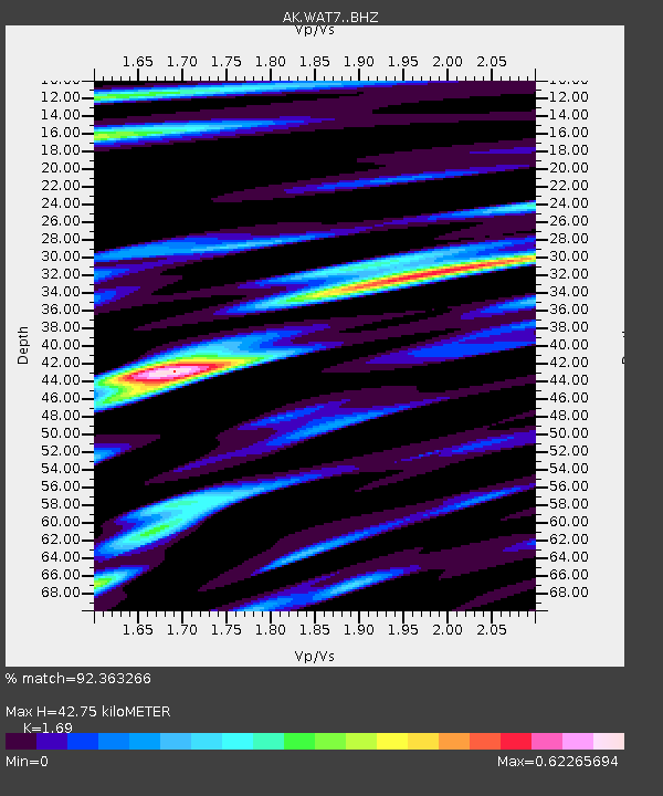
| Estimated Moho Depth: |
42.75 km |
| Estimated Crust Vp/Vs: |
1.69 |
| Assumed Crust Vp: |
6.566 km/s |
| Estimated Crust Vs: |
3.885 km/s |
| Estimated Crust Poisson's Ratio: |
0.23 |
|
| Radial Match: |
92.363266 % |
| Radial Bump: |
400 |
| Transverse Match: |
90.64086 % |
| Transverse Bump: |
400 |
| SOD ConfigId: |
25131211 |
| Insert Time: |
2021-09-19 17:56:20.676 +0000 |
| GWidth: |
2.5 |
| Max Bumps: |
400 |
| Tol: |
0.001 |
|

Signal To Noise
| Channel | StoN | STA | LTA |
| AK:WAT7: :BHZ:20210905T18:03:56.088019Z | 23.13139 | 1.3148494E-6 | 5.6842648E-8 |
| AK:WAT7: :BHN:20210905T18:03:56.088019Z | 9.524824 | 3.638964E-7 | 3.820505E-8 |
| AK:WAT7: :BHE:20210905T18:03:56.088019Z | 3.0126681 | 1.4652058E-7 | 4.863482E-8 |
| Arrivals |
| Ps | 4.6 SECOND |
| PpPs | 17 SECOND |
| PsPs/PpSs | 22 SECOND |


