You are here: Home > Network List > AV - Alaska Volcano Observatory Stations List
> Station ADAG Mount Adagdak, Regional Station, Alaska > Earthquake Result Viewer
ADAG Mount Adagdak, Regional Station, Alaska - Earthquake Result Viewer
| Earthquake location: |
Tonga Islands Region |
| Earthquake latitude/longitude: |
-22.1/-174.2 |
| Earthquake time(UTC): |
2021/09/05 (248) 17:51:42 GMT |
| Earthquake Depth: |
10 km |
| Earthquake Magnitude: |
5.9 mww |
| Earthquake Catalog/Contributor: |
NEIC PDE/us |
|
| Network: |
AV Alaska Volcano Observatory |
| Station: |
ADAG Mount Adagdak, Regional Station, Alaska |
| Lat/Lon: |
51.98 N/176.60 W |
| Elevation: |
281 m |
|
| Distance: |
73.8 deg |
| Az: |
358.432 deg |
| Baz: |
177.648 deg |
| Ray Param: |
0.052782904 |
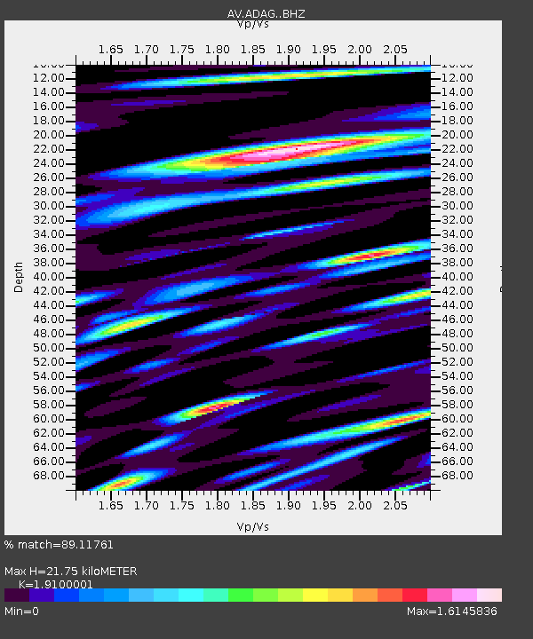
| Estimated Moho Depth: |
21.75 km |
| Estimated Crust Vp/Vs: |
1.91 |
| Assumed Crust Vp: |
5.88 km/s |
| Estimated Crust Vs: |
3.079 km/s |
| Estimated Crust Poisson's Ratio: |
0.31 |
|
| Radial Match: |
89.11761 % |
| Radial Bump: |
400 |
| Transverse Match: |
83.8442 % |
| Transverse Bump: |
400 |
| SOD ConfigId: |
25131211 |
| Insert Time: |
2021-09-19 17:57:33.775 +0000 |
| GWidth: |
2.5 |
| Max Bumps: |
400 |
| Tol: |
0.001 |
|
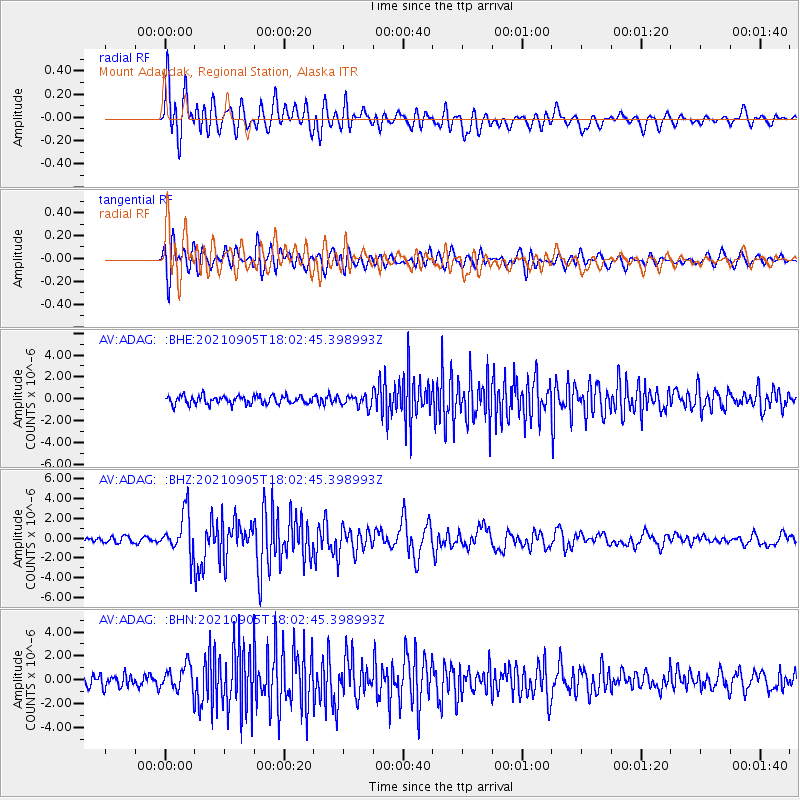
Signal To Noise
| Channel | StoN | STA | LTA |
| AV:ADAG: :BHZ:20210905T18:02:45.398993Z | 9.126851 | 2.1503317E-6 | 2.35605E-7 |
| AV:ADAG: :BHN:20210905T18:02:45.398993Z | 2.5190182 | 1.1286595E-6 | 4.4805535E-7 |
| AV:ADAG: :BHE:20210905T18:02:45.398993Z | 1.43534 | 5.383644E-7 | 3.7507795E-7 |
| Arrivals |
| Ps | 3.5 SECOND |
| PpPs | 10 SECOND |
| PsPs/PpSs | 14 SECOND |


