You are here: Home > Network List > AV - Alaska Volcano Observatory Stations List
> Station CESW Southwest, Cerberus Volcano, Alaska > Earthquake Result Viewer
CESW Southwest, Cerberus Volcano, Alaska - Earthquake Result Viewer
| Earthquake location: |
Tonga Islands Region |
| Earthquake latitude/longitude: |
-22.1/-174.2 |
| Earthquake time(UTC): |
2021/09/05 (248) 17:51:42 GMT |
| Earthquake Depth: |
10 km |
| Earthquake Magnitude: |
5.9 mww |
| Earthquake Catalog/Contributor: |
NEIC PDE/us |
|
| Network: |
AV Alaska Volcano Observatory |
| Station: |
CESW Southwest, Cerberus Volcano, Alaska |
| Lat/Lon: |
51.90 N/179.56 E |
| Elevation: |
238 m |
|
| Distance: |
73.9 deg |
| Az: |
355.959 deg |
| Baz: |
173.945 deg |
| Ray Param: |
0.05272324 |
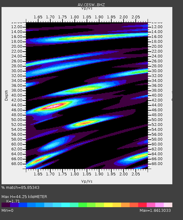
| Estimated Moho Depth: |
44.25 km |
| Estimated Crust Vp/Vs: |
1.71 |
| Assumed Crust Vp: |
6.183 km/s |
| Estimated Crust Vs: |
3.616 km/s |
| Estimated Crust Poisson's Ratio: |
0.24 |
|
| Radial Match: |
85.85343 % |
| Radial Bump: |
400 |
| Transverse Match: |
77.308754 % |
| Transverse Bump: |
400 |
| SOD ConfigId: |
25131211 |
| Insert Time: |
2021-09-19 17:58:08.558 +0000 |
| GWidth: |
2.5 |
| Max Bumps: |
400 |
| Tol: |
0.001 |
|

Signal To Noise
| Channel | StoN | STA | LTA |
| AV:CESW: :BHZ:20210905T18:02:45.958991Z | 4.9853067 | 1.3009333E-6 | 2.6095353E-7 |
| AV:CESW: :BHN:20210905T18:02:45.958991Z | 1.5008013 | 8.6273997E-7 | 5.748529E-7 |
| AV:CESW: :BHE:20210905T18:02:45.958991Z | 1.0802729 | 7.6293037E-7 | 7.0623855E-7 |
| Arrivals |
| Ps | 5.2 SECOND |
| PpPs | 19 SECOND |
| PsPs/PpSs | 24 SECOND |


