You are here: Home > Network List > AV - Alaska Volcano Observatory Stations List
> Station GALA Lava Point, Gareloi Volcano, Alaska > Earthquake Result Viewer
GALA Lava Point, Gareloi Volcano, Alaska - Earthquake Result Viewer
| Earthquake location: |
Tonga Islands Region |
| Earthquake latitude/longitude: |
-22.1/-174.2 |
| Earthquake time(UTC): |
2021/09/05 (248) 17:51:42 GMT |
| Earthquake Depth: |
10 km |
| Earthquake Magnitude: |
5.9 mww |
| Earthquake Catalog/Contributor: |
NEIC PDE/us |
|
| Network: |
AV Alaska Volcano Observatory |
| Station: |
GALA Lava Point, Gareloi Volcano, Alaska |
| Lat/Lon: |
51.76 N/178.77 W |
| Elevation: |
315 m |
|
| Distance: |
73.6 deg |
| Az: |
357.018 deg |
| Baz: |
175.547 deg |
| Ray Param: |
0.05287006 |
| Estimated Moho Depth: |
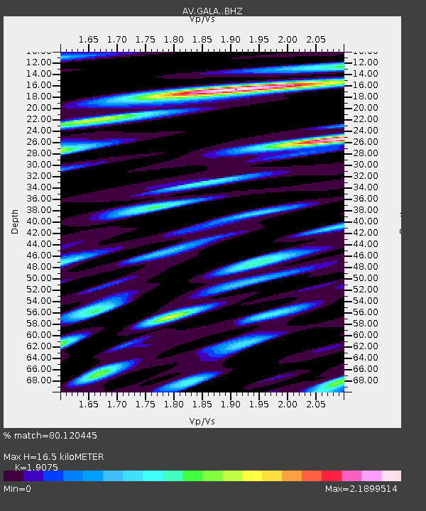
16.5 km |
| Estimated Crust Vp/Vs: |
1.91 |
| Assumed Crust Vp: |
6.048 km/s |
| Estimated Crust Vs: |
3.171 km/s |
| Estimated Crust Poisson's Ratio: |
0.31 |
|
| Radial Match: |
80.120445 % |
| Radial Bump: |
400 |
| Transverse Match: |
76.52503 % |
| Transverse Bump: |
400 |
| SOD ConfigId: |
25131211 |
| Insert Time: |
2021-09-19 17:58:21.077 +0000 |
| GWidth: |
2.5 |
| Max Bumps: |
400 |
| Tol: |
0.001 |
|

Signal To Noise
| Channel | StoN | STA | LTA |
| AV:GALA: :BHZ:20210905T18:02:44.580023Z | 4.8912406 | 1.7482863E-6 | 3.5743207E-7 |
| AV:GALA: :BHN:20210905T18:02:44.580023Z | 1.4401841 | 2.0108432E-6 | 1.3962404E-6 |
| AV:GALA: :BHE:20210905T18:02:44.580023Z | 1.2342181 | 1.7446336E-6 | 1.4135537E-6 |
| Arrivals |
| Ps | 2.5 SECOND |
| PpPs | 7.7 SECOND |
| PsPs/PpSs | 10 SECOND |


