You are here: Home > Network List > AV - Alaska Volcano Observatory Stations List
> Station GSMY Middle Yoke Creek, Great Sitkin Volcano, Alaska > Earthquake Result Viewer
GSMY Middle Yoke Creek, Great Sitkin Volcano, Alaska - Earthquake Result Viewer
| Earthquake location: |
Tonga Islands Region |
| Earthquake latitude/longitude: |
-22.1/-174.2 |
| Earthquake time(UTC): |
2021/09/05 (248) 17:51:42 GMT |
| Earthquake Depth: |
10 km |
| Earthquake Magnitude: |
5.9 mww |
| Earthquake Catalog/Contributor: |
NEIC PDE/us |
|
| Network: |
AV Alaska Volcano Observatory |
| Station: |
GSMY Middle Yoke Creek, Great Sitkin Volcano, Alaska |
| Lat/Lon: |
52.04 N/176.06 W |
| Elevation: |
418 m |
|
| Distance: |
73.8 deg |
| Az: |
358.783 deg |
| Baz: |
178.173 deg |
| Ray Param: |
0.052751597 |
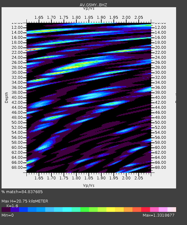
| Estimated Moho Depth: |
20.75 km |
| Estimated Crust Vp/Vs: |
1.60 |
| Assumed Crust Vp: |
3.912 km/s |
| Estimated Crust Vs: |
2.445 km/s |
| Estimated Crust Poisson's Ratio: |
0.18 |
|
| Radial Match: |
84.837685 % |
| Radial Bump: |
400 |
| Transverse Match: |
69.28458 % |
| Transverse Bump: |
400 |
| SOD ConfigId: |
25131211 |
| Insert Time: |
2021-09-19 17:58:29.625 +0000 |
| GWidth: |
2.5 |
| Max Bumps: |
400 |
| Tol: |
0.001 |
|

Signal To Noise
| Channel | StoN | STA | LTA |
| AV:GSMY: :BHZ:20210905T18:02:45.700019Z | 14.23689 | 1.6415278E-6 | 1.1530101E-7 |
| AV:GSMY: :BHN:20210905T18:02:45.700019Z | 4.290037 | 1.0708625E-6 | 2.496161E-7 |
| AV:GSMY: :BHE:20210905T18:02:45.700019Z | 2.0272722 | 4.6740746E-7 | 2.3055979E-7 |
| Arrivals |
| Ps | 3.2 SECOND |
| PpPs | 14 SECOND |
| PsPs/PpSs | 17 SECOND |


