You are here: Home > Network List > AV - Alaska Volcano Observatory Stations List
> Station KAVE Katnai Ventifact, Alaska > Earthquake Result Viewer
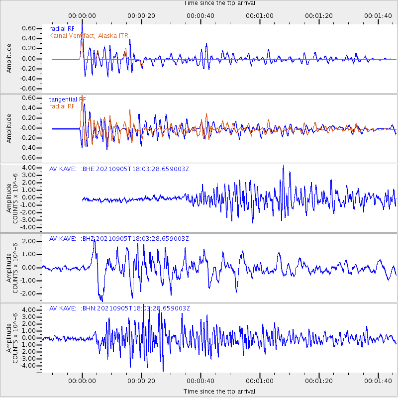
KAVE Katnai Ventifact, Alaska - Earthquake Result Viewer
*The percent match for this event was below the threshold and hence no stack was calculated.
| Earthquake location: |
Tonga Islands Region |
| Earthquake latitude/longitude: |
-22.1/-174.2 |
| Earthquake time(UTC): |
2021/09/05 (248) 17:51:42 GMT |
| Earthquake Depth: |
10 km |
| Earthquake Magnitude: |
5.9 mww |
| Earthquake Catalog/Contributor: |
NEIC PDE/us |
|
| Network: |
AV Alaska Volcano Observatory |
| Station: |
KAVE Katnai Ventifact, Alaska |
| Lat/Lon: |
58.20 N/155.02 W |
| Elevation: |
702 m |
|
| Distance: |
81.6 deg |
| Az: |
10.111 deg |
| Baz: |
197.907 deg |
| Ray Param: |
$rayparam |
*The percent match for this event was below the threshold and hence was not used in the summary stack. |
|
| Radial Match: |
79.47048 % |
| Radial Bump: |
400 |
| Transverse Match: |
69.08896 % |
| Transverse Bump: |
400 |
| SOD ConfigId: |
25131211 |
| Insert Time: |
2021-09-19 17:58:50.252 +0000 |
| GWidth: |
2.5 |
| Max Bumps: |
400 |
| Tol: |
0.001 |
|
Signal To Noise
| Channel | StoN | STA | LTA |
| AV:KAVE: :BHZ:20210905T18:03:28.659003Z | 9.195835 | 8.1797305E-7 | 8.895038E-8 |
| AV:KAVE: :BHN:20210905T18:03:28.659003Z | 2.2944198 | 3.661732E-7 | 1.5959293E-7 |
| AV:KAVE: :BHE:20210905T18:03:28.659003Z | 1.8338478 | 3.132016E-7 | 1.7078932E-7 |
| Arrivals |
| Ps | |
| PpPs | |
| PsPs/PpSs | |


