You are here: Home > Network List > AV - Alaska Volcano Observatory Stations List
> Station KAWH Katmai, Alaska > Earthquake Result Viewer
KAWH Katmai, Alaska - Earthquake Result Viewer
| Earthquake location: |
Tonga Islands Region |
| Earthquake latitude/longitude: |
-22.1/-174.2 |
| Earthquake time(UTC): |
2021/09/05 (248) 17:51:42 GMT |
| Earthquake Depth: |
10 km |
| Earthquake Magnitude: |
5.9 mww |
| Earthquake Catalog/Contributor: |
NEIC PDE/us |
|
| Network: |
AV Alaska Volcano Observatory |
| Station: |
KAWH Katmai, Alaska |
| Lat/Lon: |
58.38 N/154.80 W |
| Elevation: |
777 m |
|
| Distance: |
81.8 deg |
| Az: |
10.166 deg |
| Baz: |
198.104 deg |
| Ray Param: |
0.047357406 |
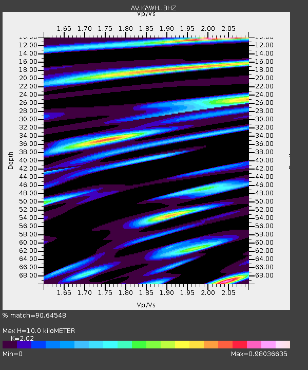
| Estimated Moho Depth: |
10.0 km |
| Estimated Crust Vp/Vs: |
2.02 |
| Assumed Crust Vp: |
6.438 km/s |
| Estimated Crust Vs: |
3.187 km/s |
| Estimated Crust Poisson's Ratio: |
0.34 |
|
| Radial Match: |
90.64548 % |
| Radial Bump: |
400 |
| Transverse Match: |
85.78538 % |
| Transverse Bump: |
400 |
| SOD ConfigId: |
25131211 |
| Insert Time: |
2021-09-19 17:58:51.999 +0000 |
| GWidth: |
2.5 |
| Max Bumps: |
400 |
| Tol: |
0.001 |
|

Signal To Noise
| Channel | StoN | STA | LTA |
| AV:KAWH: :BHZ:20210905T18:03:29.778998Z | 10.529597 | 7.2072464E-7 | 6.84475E-8 |
| AV:KAWH: :BHN:20210905T18:03:29.778998Z | 3.4182644 | 2.4817484E-7 | 7.260259E-8 |
| AV:KAWH: :BHE:20210905T18:03:29.778998Z | 2.2114398 | 1.2356159E-7 | 5.5873823E-8 |
| Arrivals |
| Ps | 1.6 SECOND |
| PpPs | 4.6 SECOND |
| PsPs/PpSs | 6.2 SECOND |


