You are here: Home > Network List > AV - Alaska Volcano Observatory Stations List
> Station KINC North Cape, Kanaga Volcano, Alaska > Earthquake Result Viewer
KINC North Cape, Kanaga Volcano, Alaska - Earthquake Result Viewer
| Earthquake location: |
Tonga Islands Region |
| Earthquake latitude/longitude: |
-22.1/-174.2 |
| Earthquake time(UTC): |
2021/09/05 (248) 17:51:42 GMT |
| Earthquake Depth: |
10 km |
| Earthquake Magnitude: |
5.9 mww |
| Earthquake Catalog/Contributor: |
NEIC PDE/us |
|
| Network: |
AV Alaska Volcano Observatory |
| Station: |
KINC North Cape, Kanaga Volcano, Alaska |
| Lat/Lon: |
51.93 N/177.13 W |
| Elevation: |
198 m |
|
| Distance: |
73.7 deg |
| Az: |
358.089 deg |
| Baz: |
177.137 deg |
| Ray Param: |
0.052804265 |
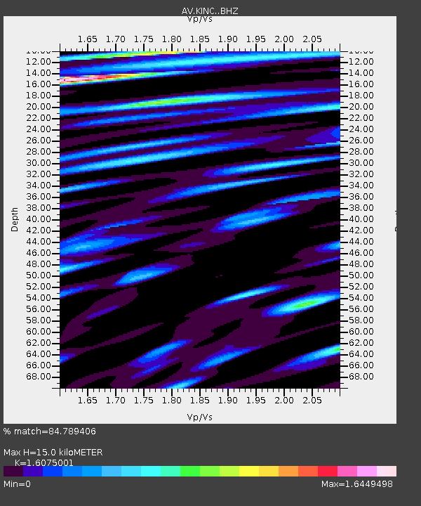
| Estimated Moho Depth: |
15.0 km |
| Estimated Crust Vp/Vs: |
1.61 |
| Assumed Crust Vp: |
5.88 km/s |
| Estimated Crust Vs: |
3.658 km/s |
| Estimated Crust Poisson's Ratio: |
0.18 |
|
| Radial Match: |
84.789406 % |
| Radial Bump: |
400 |
| Transverse Match: |
78.66421 % |
| Transverse Bump: |
400 |
| SOD ConfigId: |
25131211 |
| Insert Time: |
2021-09-19 17:58:57.876 +0000 |
| GWidth: |
2.5 |
| Max Bumps: |
400 |
| Tol: |
0.001 |
|

Signal To Noise
| Channel | StoN | STA | LTA |
| AV:KINC: :BHZ:20210905T18:02:45.200019Z | 10.603535 | 1.4203231E-6 | 1.3394808E-7 |
| AV:KINC: :BHN:20210905T18:02:45.200019Z | 1.7292377 | 4.779452E-7 | 2.763907E-7 |
| AV:KINC: :BHE:20210905T18:02:45.200019Z | 1.9503211 | 6.9269305E-7 | 3.551687E-7 |
| Arrivals |
| Ps | 1.6 SECOND |
| PpPs | 6.4 SECOND |
| PsPs/PpSs | 8.0 SECOND |


