You are here: Home > Network List > AV - Alaska Volcano Observatory Stations List
> Station KOKL Mount Kliuchef, Korovin Volcano, Alaska > Earthquake Result Viewer
KOKL Mount Kliuchef, Korovin Volcano, Alaska - Earthquake Result Viewer
| Earthquake location: |
Tonga Islands Region |
| Earthquake latitude/longitude: |
-22.1/-174.2 |
| Earthquake time(UTC): |
2021/09/05 (248) 17:51:42 GMT |
| Earthquake Depth: |
10 km |
| Earthquake Magnitude: |
5.9 mww |
| Earthquake Catalog/Contributor: |
NEIC PDE/us |
|
| Network: |
AV Alaska Volcano Observatory |
| Station: |
KOKL Mount Kliuchef, Korovin Volcano, Alaska |
| Lat/Lon: |
52.32 N/174.20 W |
| Elevation: |
758 m |
|
| Distance: |
74.1 deg |
| Az: |
359.977 deg |
| Baz: |
179.965 deg |
| Ray Param: |
0.05257964 |
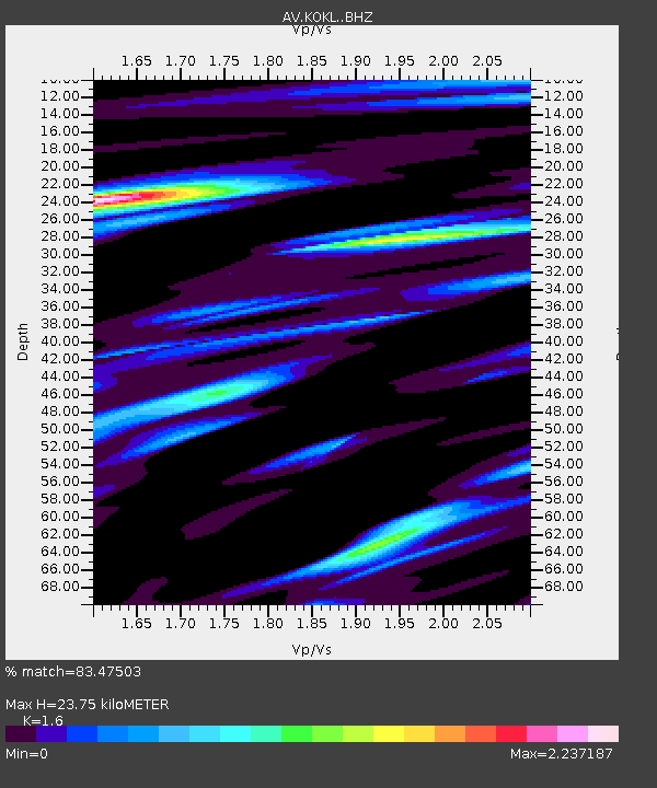
| Estimated Moho Depth: |
23.75 km |
| Estimated Crust Vp/Vs: |
1.60 |
| Assumed Crust Vp: |
5.88 km/s |
| Estimated Crust Vs: |
3.675 km/s |
| Estimated Crust Poisson's Ratio: |
0.18 |
|
| Radial Match: |
83.47503 % |
| Radial Bump: |
400 |
| Transverse Match: |
82.56075 % |
| Transverse Bump: |
400 |
| SOD ConfigId: |
25131211 |
| Insert Time: |
2021-09-19 17:59:04.179 +0000 |
| GWidth: |
2.5 |
| Max Bumps: |
400 |
| Tol: |
0.001 |
|

Signal To Noise
| Channel | StoN | STA | LTA |
| AV:KOKL: :BHZ:20210905T18:02:47.219Z | 6.413836 | 1.5218674E-6 | 2.3727881E-7 |
| AV:KOKL: :BHN:20210905T18:02:47.219Z | 3.8106515 | 1.4501575E-6 | 3.8055367E-7 |
| AV:KOKL: :BHE:20210905T18:02:47.219Z | 1.6735023 | 5.3413265E-7 | 3.1917054E-7 |
| Arrivals |
| Ps | 2.5 SECOND |
| PpPs | 10 SECOND |
| PsPs/PpSs | 13 SECOND |


