You are here: Home > Network List > AV - Alaska Volcano Observatory Stations List
> Station SPNN North Nagishlamina, Mount Spurr, Alaska > Earthquake Result Viewer
SPNN North Nagishlamina, Mount Spurr, Alaska - Earthquake Result Viewer
| Earthquake location: |
Tonga Islands Region |
| Earthquake latitude/longitude: |
-22.1/-174.2 |
| Earthquake time(UTC): |
2021/09/05 (248) 17:51:42 GMT |
| Earthquake Depth: |
10 km |
| Earthquake Magnitude: |
5.9 mww |
| Earthquake Catalog/Contributor: |
NEIC PDE/us |
|
| Network: |
AV Alaska Volcano Observatory |
| Station: |
SPNN North Nagishlamina, Mount Spurr, Alaska |
| Lat/Lon: |
61.37 N/152.70 W |
| Elevation: |
1666 m |
|
| Distance: |
84.9 deg |
| Az: |
10.193 deg |
| Baz: |
199.921 deg |
| Ray Param: |
0.04512346 |
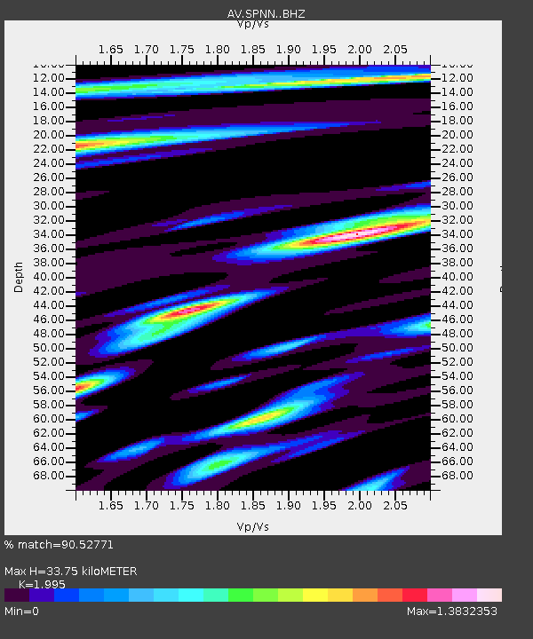
| Estimated Moho Depth: |
33.75 km |
| Estimated Crust Vp/Vs: |
2.00 |
| Assumed Crust Vp: |
6.566 km/s |
| Estimated Crust Vs: |
3.291 km/s |
| Estimated Crust Poisson's Ratio: |
0.33 |
|
| Radial Match: |
90.52771 % |
| Radial Bump: |
400 |
| Transverse Match: |
86.84145 % |
| Transverse Bump: |
400 |
| SOD ConfigId: |
25131211 |
| Insert Time: |
2021-09-19 18:00:14.327 +0000 |
| GWidth: |
2.5 |
| Max Bumps: |
400 |
| Tol: |
0.001 |
|

Signal To Noise
| Channel | StoN | STA | LTA |
| AV:SPNN: :BHZ:20210905T18:03:46.060004Z | 16.399221 | 6.089908E-7 | 3.7135344E-8 |
| AV:SPNN: :BHN:20210905T18:03:46.060004Z | 4.494064 | 1.6143963E-7 | 3.5922863E-8 |
| AV:SPNN: :BHE:20210905T18:03:46.060004Z | 2.5548747 | 1.1782895E-7 | 4.6119265E-8 |
| Arrivals |
| Ps | 5.2 SECOND |
| PpPs | 15 SECOND |
| PsPs/PpSs | 20 SECOND |


