You are here: Home > Network List > G - GEOSCOPE Stations List
> Station NOUC Port Laguerre, New Caledonia > Earthquake Result Viewer
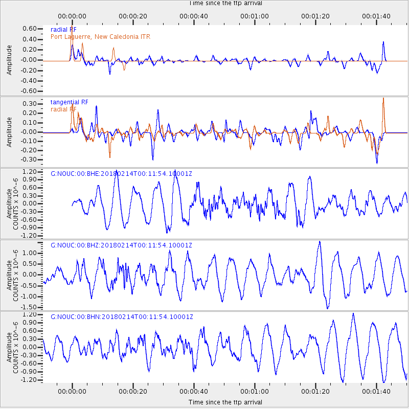
NOUC Port Laguerre, New Caledonia - Earthquake Result Viewer
*The percent match for this event was below the threshold and hence no stack was calculated.
| Earthquake location: |
Aru Islands Region, Indonesia |
| Earthquake latitude/longitude: |
-6.0/133.8 |
| Earthquake time(UTC): |
2018/02/14 (045) 00:05:30 GMT |
| Earthquake Depth: |
10 km |
| Earthquake Magnitude: |
5.5 mb |
| Earthquake Catalog/Contributor: |
NEIC PDE/us |
|
| Network: |
G GEOSCOPE |
| Station: |
NOUC Port Laguerre, New Caledonia |
| Lat/Lon: |
22.10 S/166.30 E |
| Elevation: |
112 m |
|
| Distance: |
35.2 deg |
| Az: |
120.273 deg |
| Baz: |
292.148 deg |
| Ray Param: |
$rayparam |
*The percent match for this event was below the threshold and hence was not used in the summary stack. |
|
| Radial Match: |
59.83905 % |
| Radial Bump: |
400 |
| Transverse Match: |
63.021507 % |
| Transverse Bump: |
400 |
| SOD ConfigId: |
2615551 |
| Insert Time: |
2018-03-14 22:32:12.622 +0000 |
| GWidth: |
2.5 |
| Max Bumps: |
400 |
| Tol: |
0.001 |
|
Signal To Noise
| Channel | StoN | STA | LTA |
| G:NOUC:00:BHZ:20180214T00:11:54.10001Z | 1.086611 | 3.7164267E-7 | 3.4202E-7 |
| G:NOUC:00:BHN:20180214T00:11:54.10001Z | 0.4498216 | 2.271263E-7 | 5.049253E-7 |
| G:NOUC:00:BHE:20180214T00:11:54.10001Z | 1.55874 | 7.869292E-7 | 5.048496E-7 |
| Arrivals |
| Ps | |
| PpPs | |
| PsPs/PpSs | |


