You are here: Home > Network List > AV - Alaska Volcano Observatory Stations List
> Station TAFP Falls Point, Tanaga Volcano, Alaska > Earthquake Result Viewer
TAFP Falls Point, Tanaga Volcano, Alaska - Earthquake Result Viewer
| Earthquake location: |
Tonga Islands Region |
| Earthquake latitude/longitude: |
-22.1/-174.2 |
| Earthquake time(UTC): |
2021/09/05 (248) 17:51:42 GMT |
| Earthquake Depth: |
10 km |
| Earthquake Magnitude: |
5.9 mww |
| Earthquake Catalog/Contributor: |
NEIC PDE/us |
|
| Network: |
AV Alaska Volcano Observatory |
| Station: |
TAFP Falls Point, Tanaga Volcano, Alaska |
| Lat/Lon: |
51.90 N/177.99 W |
| Elevation: |
440 m |
|
| Distance: |
73.7 deg |
| Az: |
357.536 deg |
| Baz: |
176.311 deg |
| Ray Param: |
0.052804865 |
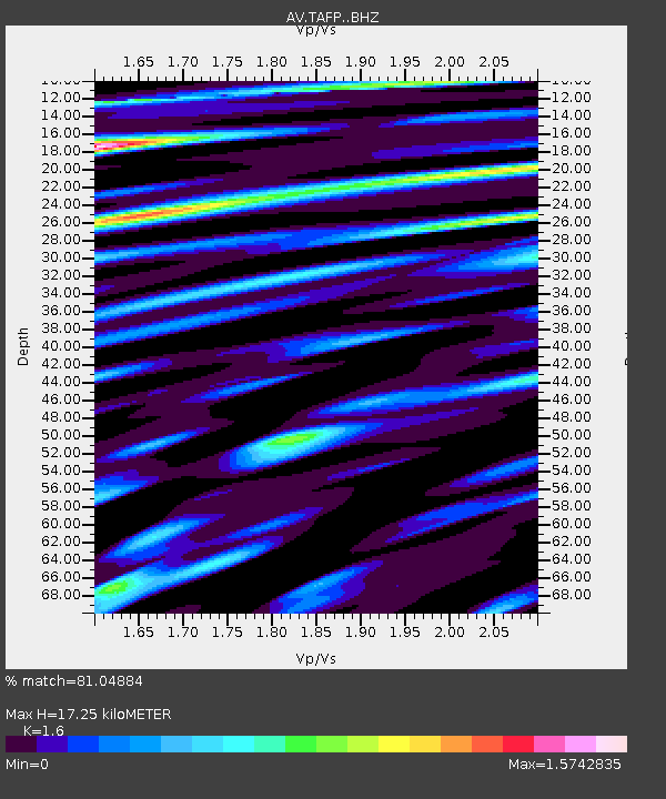
| Estimated Moho Depth: |
17.25 km |
| Estimated Crust Vp/Vs: |
1.60 |
| Assumed Crust Vp: |
5.88 km/s |
| Estimated Crust Vs: |
3.675 km/s |
| Estimated Crust Poisson's Ratio: |
0.18 |
|
| Radial Match: |
81.04884 % |
| Radial Bump: |
400 |
| Transverse Match: |
71.56503 % |
| Transverse Bump: |
400 |
| SOD ConfigId: |
25131211 |
| Insert Time: |
2021-09-19 18:00:23.396 +0000 |
| GWidth: |
2.5 |
| Max Bumps: |
400 |
| Tol: |
0.001 |
|

Signal To Noise
| Channel | StoN | STA | LTA |
| AV:TAFP: :BHZ:20210905T18:02:45.200019Z | 7.7456284 | 1.2096118E-6 | 1.5616703E-7 |
| AV:TAFP: :BHN:20210905T18:02:45.200019Z | 1.708781 | 3.9623072E-7 | 2.3187917E-7 |
| AV:TAFP: :BHE:20210905T18:02:45.200019Z | 1.6231095 | 3.2108568E-7 | 1.9782134E-7 |
| Arrivals |
| Ps | 1.8 SECOND |
| PpPs | 7.4 SECOND |
| PsPs/PpSs | 9.2 SECOND |


