You are here: Home > Network List > GM - US Geological Survey Networks Stations List
> Station NMP44 New Mexico Permian - Site# W4S4 > Earthquake Result Viewer
NMP44 New Mexico Permian - Site# W4S4 - Earthquake Result Viewer
| Earthquake location: |
Tonga Islands Region |
| Earthquake latitude/longitude: |
-22.1/-174.2 |
| Earthquake time(UTC): |
2021/09/05 (248) 17:51:42 GMT |
| Earthquake Depth: |
10 km |
| Earthquake Magnitude: |
5.9 mww |
| Earthquake Catalog/Contributor: |
NEIC PDE/us |
|
| Network: |
GM US Geological Survey Networks |
| Station: |
NMP44 New Mexico Permian - Site# W4S4 |
| Lat/Lon: |
32.20 N/103.62 W |
| Elevation: |
1086 m |
|
| Distance: |
86.4 deg |
| Az: |
53.224 deg |
| Baz: |
241.199 deg |
| Ray Param: |
0.04411172 |
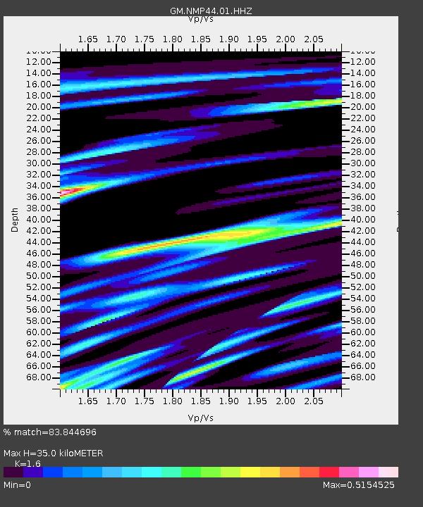
| Estimated Moho Depth: |
35.0 km |
| Estimated Crust Vp/Vs: |
1.60 |
| Assumed Crust Vp: |
6.129 km/s |
| Estimated Crust Vs: |
3.831 km/s |
| Estimated Crust Poisson's Ratio: |
0.18 |
|
| Radial Match: |
83.844696 % |
| Radial Bump: |
400 |
| Transverse Match: |
52.657433 % |
| Transverse Bump: |
400 |
| SOD ConfigId: |
25131211 |
| Insert Time: |
2021-09-19 18:05:34.270 +0000 |
| GWidth: |
2.5 |
| Max Bumps: |
400 |
| Tol: |
0.001 |
|

Signal To Noise
| Channel | StoN | STA | LTA |
| GM:NMP44:01:HHZ:20210905T18:03:53.039984Z | 1.578806 | 1.096415E-6 | 6.9445827E-7 |
| GM:NMP44:01:HHN:20210905T18:03:53.039984Z | 0.7944964 | 2.7454848E-7 | 3.455629E-7 |
| GM:NMP44:01:HHE:20210905T18:03:53.039984Z | 1.7687445 | 5.214133E-7 | 2.947929E-7 |
| Arrivals |
| Ps | 3.5 SECOND |
| PpPs | 15 SECOND |
| PsPs/PpSs | 18 SECOND |


