You are here: Home > Network List > TX - Texas Seismological Network Stations List
> Station MB07 West Midland > Earthquake Result Viewer
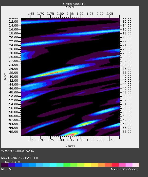
MB07 West Midland - Earthquake Result Viewer
| Earthquake location: |
Tonga Islands Region |
| Earthquake latitude/longitude: |
-22.1/-174.2 |
| Earthquake time(UTC): |
2021/09/05 (248) 17:51:42 GMT |
| Earthquake Depth: |
10 km |
| Earthquake Magnitude: |
5.9 mww |
| Earthquake Catalog/Contributor: |
NEIC PDE/us |
|
| Network: |
TX Texas Seismological Network |
| Station: |
MB07 West Midland |
| Lat/Lon: |
32.00 N/102.25 W |
| Elevation: |
880 m |
|
| Distance: |
87.3 deg |
| Az: |
53.956 deg |
| Baz: |
241.962 deg |
| Ray Param: |
0.043436732 |
| Estimated Moho Depth: |
69.75 km |
| Estimated Crust Vp/Vs: |
1.84 |
| Assumed Crust Vp: |
6.129 km/s |
| Estimated Crust Vs: |
3.326 km/s |
| Estimated Crust Poisson's Ratio: |
0.29 |
|
| Radial Match: |
88.015236 % |
| Radial Bump: |
400 |
| Transverse Match: |
57.592052 % |
| Transverse Bump: |
400 |
| SOD ConfigId: |
25131211 |
| Insert Time: |
2021-09-19 18:12:12.853 +0000 |
| GWidth: |
2.5 |
| Max Bumps: |
400 |
| Tol: |
0.001 |
|

Signal To Noise
| Channel | StoN | STA | LTA |
| TX:MB07:00:HHZ:20210905T18:03:57.529975Z | 0.91251683 | 5.336274E-8 | 5.847864E-8 |
| TX:MB07:00:HH1:20210905T18:03:57.529975Z | 0.6796373 | 5.4550718E-8 | 8.0264456E-8 |
| TX:MB07:00:HH2:20210905T18:03:57.529975Z | 0.6385448 | 3.469628E-8 | 5.433649E-8 |
| Arrivals |
| Ps | 9.8 SECOND |
| PpPs | 32 SECOND |
| PsPs/PpSs | 41 SECOND |


